
Kumta
Kumta
Kumta | |
|---|---|
town | |
| Population (2001) | |
| • Total | 27,598 |
Kumta is a town and a taluka place in Uttara Kannada district in the Indian state of Karnataka. It is a sea-coast town and is about 60 km south of the city of Karwar and 20 km north of Honavar.
History
During the British Raj, it was a part of the North Kanara district of Bombay Presidency. It had an open roadstead, with a considerable trade, especially in cotton. Carving in sandalwood was a speciality. The commercial importance of Kumta had declined after the opening of the Southern Mahratta railway system.
The town of Kumta is located on the Arabian sea coast in the district of Uttara Kannada in the state of Karnataka. Kumta has been a center for education and trade since the early part of the 20th century, when two educational institutions -- The Gibb High School and The Canara College were started.
During the American Civil War the cotton from the southern states that fed mills in England stopped supplying and the mills started importing a variety of cotton known as 'Kumta Hatti' this resulted in development of Kumta port.
Just to the north of town, the Aghanashini river joins the Arabian Sea on her way rendering stunning scenery. A nearby spot called Yana is also beautiful with its massive black rock formations and nature trails. The town of Gokarn, near Kumta is a place of pilgrimage for Hindus and is known as the Kashi of the South.
The town of Kumta features diverse population including brahmins, craftsmen, fishermen, Christians, and Muslims. Beaches, lakes (Vishnuteerth), and mountains provide a lot of recreational opportunities to the locals.
There are a lot of old temples in Kumta. Sri Kumbheshwar, Salt Ganapati, Shantika Parameshwari, Mahalasa Narayani, Shanteri Kamakshi, Kavur Kamakshi, and Shankar Narayan temples are some of them. Many of these feature period architectures and period art forms, especially the Kavi Art.
Geography
Kumta is located at 14°25′N 74°24′E / 14.42°N 74.4°E[1]. It has an average elevation of 3 metres (9 feet).
There are many tourist places nearby Kumta. Gokarna, famous for the its beach (originally famous for the temple), is just 20 km. Yana is just 20 km from Kumta. Kumta town is more famous for the temples. The taluk has 4 Beaches in it. Dhareshwar beach is very good and is located 5 km away from kumta.
-
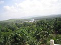 Kumta scenery with a view of Aghnashini river

Beautiful places around Kumta include:
- Kumta beach,
- Dhareshwar beach,
- Baada beach, and
- Mirjan Fort
- Masti Halla
Demographics
As of 2001 India census[2], Kumta had a population of 27,597. Males constitute 51% of the population and females 49%. Kumta has an average literacy rate of 77%, higher than the national average of 59.5%: male literacy is 82%, and female literacy is 73%. In Kumta, 10% of the population is under 6 years of age. Kannada and Konkani are spoken languages in Kumta.
Climate
The three main seasons are:
- Summer : March - Mid June.
- Rainy : Mid June - October.
- Winter : November - February.
Since the town is located on the coast, it has a moderate climate, with temperatures in the range of 360C to 280C during summer and 260C to 200C during winter. The rainy season witnesses heavy rains by the South-West Monsoon. The average annual rainfall is about 3000 mm.
Hotels and Restaurants
-
 Swastik Restaurant and Bar, Kumta
 -
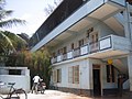
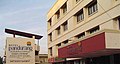 Pandurang International-Hotel and Restaurant, Kumta


Economy
Kumta is known for its betelnut, cashew, coconut, banana cultivation and fisheries.
Educational institutes of Kumta taluk
Kumta town has been a pioneer learning center in the Uttar Kannada District for many years.
- Dr. A. V. Baliga college, Kumta,
- Nirmal Convent High School,
- Gibbs High School, Kumta,
- Vidyadhiraj Polytechnic College,
- Anandashram High School, Bankikodla.
- Bhadrakali High School, Gokarna
- BBA college of the Kanara Education Society.
- B.Ed College of the Kanara Education Society.
- Shree Shantikamba High School, Hegde.
- Mahatama Gandhi HighSchool, Chitrigi, Kumta
Transportation
Road
There is a National Highway that pass through Kumta:
Rail
Kumta has a railway station on Konkan Railway.
Air
Nearest airports are Mangalore International Airport and Goa International airport.
References
External links
This article related to a location in Karnataka is a stub. You can help Wikipedia by expanding it. |