Tolmin
This article has multiple issues. Please help improve it or discuss these issues on the talk page. (Learn how and when to remove these messages)
No issues specified. Please specify issues, or remove this template. |
Template:Municipality of Slovenia Tolmin (Italian Tolmino, German Tolmein) is a small town and municipality with the same name in Slovenia
Geography
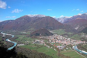
Tolmin, the old town that gave the name to the entire area (Template:Lang-sl), is the largest settlement in the Upper Soča Valley (Template:Lang-sl), as well as the economic, cultural and administrative centre of the valley. It is located on a terrace above the confluence of Soča and Tolminka rivers. It is positioned beneath steep mountainous valleys.
History
- see also Gorizia and Gradisca, Austrian Littoral, Julian March
In ancient times the area was inhabited by the Illyrians and then by the Romans. In the 6th century the Slavs, ancestors of present-day Slovenes, settled the area.
Until 1420 it belonged to the Patriarchate of Aquileia, when it was acquired by the Republic of Venice. In 1514 it became possession of the Habsburgs, who gave it as fief to the Coronini family. Medieval documents testify to a long series of uprisings, culminating in the Tolmin peasant revolt of 1713. That particular insurgence spread from the Tolmin county to the Vipava Valley, Kras, Brda and further on to northern Istria. The uprising was mercilessly crushed by the imperial army and its eleven leaders were beheaded.
In the 16th century, the area became part of the County of Gorizia and Gradisca. During the World War I, Tolmin served as a base for the victorious breach of the Soča/Isonzo Front. Between 1918 and 1943 it was part of the Kingdom of Italy, and between 1943 and 1945 of the Nazi German Operational Zone Adriatic Coast. In 1945 it was liberated by the Yugoslav partisans and in 1947 it was annexed to the Socialist Federal Republic of Yugoslavia. Since then, it has been an integral part of Slovenia.
Main sights

Tolmin's main sights are its old town centre, a modern sports park and thousand year old castle ruins at Kozlov Rob.
The area is home to a multitude of vestiges from the World War I. The most significant relic of the time is the church of the Holy Spirit at Javorca, built above the Polog shepherds outpost in the Tolminka valley by Austro-Hungarian soldiers to commemorate their deceased comrades.

The museum, library, schools and the town’s open spaces provide venues for a variety of events, exhibitions and presentations all year round. The Tolmin region is also a popular destination for Slovene and foreign artists.
Tolmin area houses the famous Tolminka and Zadlaščica basins at the entrance to Triglav National Park, which are also its lowest point (180 m). A special feature of the Tolminka basins is a thermal spring at the end of the path. The region boasts also several record-holders waterfall (Brinta Waterfall 104 m, Gregorčič Waterfall 88 m) and several smaller but no less ravishing others hidden in the ravines of the Mrzli Potok, Godiča, Pščak, and Sopotnica.
People from Tolmin
- Ivan Čargo, Painter
- Jan Cvitkovič, Film director
- Anton Haus, Grand Admiral of the Austro-Hungarian Navy
- Ciril Kosmač, Writer
- Giancarlo Movia, Philosopher
- Ivan Pregelj, Writer
- Albert Rejec, Founder and head of the TIGR
- Jožko Šavli, author and historian
- Saša Vuga, Writer
Twin towns
Trivia
Tolmin is the playground for the heavy metal festival Metalcamp and Soča Reggae Riversplash festival.
See also
External links
- Tolmin, official page of municipality Template:Sl icon
- Tolmin museum, the history of the Tolmin area, which once included also the Bovec and Kobarid areas, boasts a rich archaeological, ethnological cultural and historical heritage Template:Sl icon Template:En icon
- Knjižnica Tolmin - Tolmin Library, Ciril Kosmač Library of Tolmin Template:Sl icon Template:En icon
- LTO Sotočje, local tourist board Template:Sl icon Template:En icon Template:De icon Template:It icon
- FFA Posočje, Free Flying Association Posočje Template:Sl icon Template:En icon

