Jenks, Oklahoma
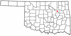
Jenks is a fast growing city located in Tulsa County, Oklahoma in the northeastern part of Oklahoma. As of the 2000 census, the city had a total population of 9,557 and is growing by about 10% per year. Jenks is a suburb to the south and west of Tulsa and lays between the Arkansas River and highway US 75. In Jenks houses sell as nearly as fast as they can be built. In 2003 alone, twenty-six subdivisions are in the planning or development process.
City
Jenks is not just a suburban bedroom community. Despite its growth, Jenks is a town known for its antique small-town charm. Along Main St., small boutiques, antique stores, and salons in historic buildings are very popular and draw visitors from all over. Growth is largely fueled by the popular public school system in Jenks which is one of the top school systems in the state. The Jenks school district encompasses significant portions of southwest Tulsa, and in fact many of the Jenks schools are located in Tulsa. The high school, though, remains near downtown Jenks.
In 2004, the new Oklahoma Aquarium opened along the Arkansas River in Jenks which started a boom in riverfront development. Two new hotels and the new Riverwalk Crossing center are being built or have been built on the river near the aquarium. A pedestrian bridge links the Jenks riverfront area with the Tulsa Riverparks system on the other side of the river. Commercial development on the river is now spreading into Tulsa as well.
Jenks is home to Tulsa’s general aviation airport Jones Airport which is the state's busiest airport and -- measured by number of takeoffs and landings -- one of the busiest in the world.
Geography

Jenks is located at 36°0'37" North, 95°58'47" West (36.010276, -95.979850)Template:GR.
According to the United States Census Bureau, the city has a total area of 38.6 km² (14.9 mi²). 37.1 km² (14.3 mi²) of it is land and 1.4 km² (0.6 mi²) of it is water. The total area is 3.69% water.
Demographics
As of the censusTemplate:GR of 2000, there are 9,557 people, 3,451 households, and 2,757 families residing in the city. The population density is 257.3/km² (666.2/mi²). There are 3,592 housing units at an average density of 96.7/km² (250.4/mi²). The racial makeup of the city is 87.39% White, 1.58% African American, 4.74% Native American, 0.81% Asian, 0.02% Pacific Islander, 1.73% from other races, and 3.74% from two or more races. 4.12% of the population are Hispanic or Latino of any race.
There are 3,451 households out of which 43.1% have children under the age of 18 living with them, 66.0% are married couples living together, 9.9% have a female householder with no husband present, and 20.1% are non-families. 18.1% of all households are made up of individuals and 7.1% have someone living alone who is 65 years of age or older. The average household size is 2.74 and the average family size is 3.12.
In the city the population is spread out with 29.7% under the age of 18, 6.6% from 18 to 24, 31.5% from 25 to 44, 23.0% from 45 to 64, and 9.1% who are 65 years of age or older. The median age is 35 years. For every 100 females there are 96.7 males. For every 100 females age 18 and over, there are 90.0 males.
The median income for a household in the city is $54,637, and the median income for a family is $61,050. Males have a median income of $42,148 versus $28,419 for females. The per capita income for the city is $22,804. 4.6% of the population and 2.6% of families are below the poverty line. Out of the total population, 6.7% of those under the age of 18 and 4.9% of those 65 and older are living below the poverty line.
Links
