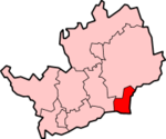
Borough of Broxbourne
Appearance
| Borough of Broxbourne | |
|---|---|
 Shown within Hertfordshire | |
| Geography | |
| Status: | Borough |
| Region: | East of England |
| Admin. County: | Hertfordshire |
| Area: - Total |
Ranked 297th 51.43 km² |
| Admin. HQ: | Cheshunt |
| ONS code: | 26UB |
| Demographics | |
| Population: - Total (2004 est.) - Density |
Ranked 268th 86,100 1,674 / km² |
| Ethnicity: | 96.1% White 1.2% S.Asian 1.2% Afro-Carib. |
| Politics | |
| Arms of Broxbourne Borough Council Broxbourne Borough Council http://www.broxbourne.gov.uk/ | |
| Leadership: | Alternative - Sec.31 |
| Control: | Conservative |
| MP: | Charles Walker |
Broxbourne is a local government district and borough in Hertfordshire, England. Its council is based in Cheshunt, other towns include Broxbourne, Hoddesdon, Waltham Cross and Goff's Oak. The eastern boundary of the district is the River Lea.
The borough was formed on April 1, 1974 by the merger of Cheshunt and Hoddesdon urban districts.
Broxbourne Borough Council has the lowest council tax in Hertfordshire and the second lowest in England. [1]

