Sluhy
Sluhy | |
|---|---|
Municipality and village | |
 Sluhy | |
 | |
| Country | |
| Region | Central Bohemian Region |
| District | Prague-East District |
| Area | |
| • Total | 1.76 sq mi (4.56 km2) |
| Elevation | 604 ft (184 m) |
| Population (2010) | |
| • Total | 695 |
| Time zone | UTC+1 (CET) |
| • Summer (DST) | UTC+2 (CEST) |
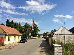
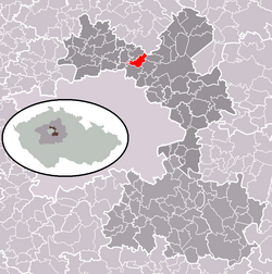
Sluhy is a village in the Central Bohemian Region of the Czech Republic. Sluhy is located nearby Prague. It is part of an administrative district Prague East and it is one of the oldest villages in country. On the date August 28, 2006 it has 652 inhabitants. First written notice about village is from year 1238, but a church of St. Vojtech, which is situated in the village, is dated from 967. Sluhy is also mentioned in Chronicle Sluzska, which was written by P.Frantisek Pubal. The chronicle describes a life of villagers in Mikroregion Povodí Mratínského potoka in 19th and 20th century.
Monuments
The other monuments in Sluhy are a bell tower nearby the cemetery and a rectory. There used to also be a gothic stronghold. Ruins of this stronghold remained in Sluhy until the 1990s.
Owners of the village Sluhy in history
- Zbraslav from Miletin
- Pribyslav from Sluhy ( a waiter of Wenceslas I )
- Sluzsti from Chlum
- Myskove from Zlunice
- Mikulas Karyk Rezna
- Vaclav Sturm from Hyrsfeldu
- Ehrenfried Berbisdorf from Berbisdorfu (His fortune was confiscated by Jesuits.)
External links
- Village website (cz)
References
- Village website(cz) Official web site of Sluhy
50°11′41″N 14°33′35″E / 50.19472°N 14.55972°E


