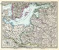
File:Stielers Handatlas 1891 46.jpg
Appearance

Size of this preview: 712 × 599 pixels. Other resolutions: 285 × 240 pixels | 570 × 480 pixels | 913 × 768 pixels | 1,217 × 1,024 pixels | 2,434 × 2,048 pixels | 5,050 × 4,250 pixels.
Original file (5,050 × 4,250 pixels, file size: 7 MB, MIME type: image/jpeg)
File history
Click on a date/time to view the file as it appeared at that time.
| Date/Time | Thumbnail | Dimensions | User | Comment | |
|---|---|---|---|---|---|
| current | 07:45, 13 March 2010 |  | 5,050 × 4,250 (7 MB) | Kolossos | better quality |
| 17:39, 21 November 2006 |  | 3,788 × 3,188 (1.47 MB) | Poccil | {{Stielers Handatlas 1891|45|47|Ost-Europa, No. 3: Süd-Schweden, die Russischen Ostsee-Provinzen, Polen & West-Russland|East Europe, no. 2: south Sweden, the Russian Baltic provinces, Poland and west Russia}} Category:Old maps of Russia |
File usage
The following page uses this file:
Global file usage
The following other wikis use this file:
- Usage on be.wikipedia.org
- Usage on ca.wikipedia.org
- Usage on cs.wikipedia.org
- Usage on et.wikipedia.org
- Usage on fr.wikipedia.org
- Usage on lt.wikipedia.org
- Usage on lt.wikibooks.org
- Usage on sr.wikipedia.org
- Usage on tg.wikipedia.org
- Usage on uk.wikipedia.org


