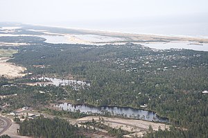
Heceta Beach, Oregon
Appearance
Heceta Beach, Oregon | |
|---|---|
 Aerial view of Heceta Beach and surroundings | |
| Coordinates: 44°2′0″N 124°7′52″W / 44.03333°N 124.13111°W | |
| Country | United States |
| State | Oregon |
| County | Lane |
| Area | |
| • Total | 2.83 sq mi (7.33 km2) |
| • Land | 2.34 sq mi (6.06 km2) |
| • Water | 0.49 sq mi (1.27 km2) |
| Population | |
| • Total | 1,912 |
| • Density | 817.44/sq mi (315.64/km2) |
| Time zone | UTC-8 (Pacific (PST)) |
| • Summer (DST) | UTC-7 (PDT) |
| ZIP code | 97439[3] |
| Area code(s) | 458 and 541 |
| FIPS code | 41-33150 |
Heceta Beach is an unincorporated community in Lane County, Oregon, United States, located west of U.S. Route 101 next to the Pacific Ocean. It is the next settlement north of the Siuslaw River and Florence and is within the Florence urban growth boundary.[4] Heceta Beach was platted in 1915.[5] Lane County maintains a small county park there, with beach access, as well as restrooms and picnic tables.[6]
Driftwood Shores, a hotel and conference center in Heceta Beach, was annexed to Florence in 2008.[7]
Demographics
[edit]| Census | Pop. | Note | %± |
|---|---|---|---|
| 2020 | 1,912 | — | |
| U.S. Decennial Census[8][2] | |||
See also
[edit]References
[edit]- ^ "ArcGIS REST Services Directory". United States Census Bureau. Retrieved October 12, 2022.
- ^ a b "Census Population API". United States Census Bureau. Retrieved October 12, 2022.
- ^ "Heceta Beach OR ZIP Code". zipdatamaps.com. 2023. Retrieved June 16, 2023.
- ^ City of Florence Zoning Map[permanent dead link]
- ^ "In the Matter of Denying the Petition to Vacate Portions of First Avenue" (PDF). Lane County, Oregon. August 31, 2008. Retrieved March 19, 2009.
- ^ "All Parks-F to J". Lane County, Oregon. Archived from the original on October 16, 2007. Retrieved March 19, 2009.
- ^ Penrod, Shawn, Shawn (January 13, 2009). "Beach contamination gains attention from city, county". Siuslaw News. Archived from the original on February 16, 2012. Retrieved March 20, 2009.
- ^ "Census of Population and Housing". Census.gov. Retrieved June 4, 2016.


