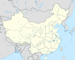
Loping Airfield
| Loping Airfield | |
|---|---|
| Part of Fourteenth Air Force | |
| Yunnan Province, China | |
| Coordinates | 24°50′48″N 104°18′34″E / 24.84667°N 104.30944°E |
| Type | Military airfield |
| Site information | |
| Controlled by | United States Army Air Forces |
| Site history | |
| Battles/wars | China Defensive Campaign 1942-1945 |
Loping Airfield is a former World War II United States Army Air Forces airfield in the People’s Republic of China, located approximately 3 miles south of the community of Luoping in Luoping County (Yunnan Province).
History
[edit]The airfield was a primary transport base on the Chinese side of "the Hump" air supply route over the Himalayan Mountains, which was used by Air Transport Command for the transhipment of supplies from airfields in the Assam Valley of India. In 1945, Fourteenth Air Force also used the airfield as a transport base, primarily moving Chinese troops and their equipment from the base to other locations in China. The Americans used the base until the end of December 1945, when they closed their facilities at the station.
The runway is not now used for fixed wing aircraft. A resort facility has been developed at the south end of the runway for housing visitors and providing them helicopter service to view canola crops when they are in blossom.
References
[edit]![]() This article incorporates public domain material from the Air Force Historical Research Agency
This article incorporates public domain material from the Air Force Historical Research Agency
- Maurer, Maurer. Air Force Combat Units Of World War II. Maxwell Air Force Base, Alabama: Office of Air Force History, 1983. ISBN 0-89201-092-4
- USAFHRA document search - Loping


