Mueang Nong Khai district
Mueang Nong Khai
เมืองหนองคาย | |
|---|---|
 | |
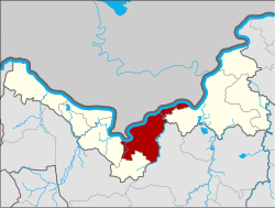
 District location in Nong Khai province | |
| Coordinates: 17°52′48″N 102°44′30″E / 17.88000°N 102.74167°E | |
| Country | Thailand |
| Province | Nong Khai |
| Seat | Nong Kom Ko |
| Area | |
| • Total | 607.5 km2 (234.6 sq mi) |
| Population (2008) | |
| • Total | 145,153 |
| • Density | 235.1/km2 (609/sq mi) |
| Time zone | UTC+7 (ICT) |
| Postal code | 43000 |
| Geocode | 4301 |
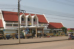
Mueang Nong Khai (Thai: เมืองหนองคาย, pronounced [mɯ̄a̯ŋ nɔ̌ːŋ kʰāːj]) is the capital district (amphoe mueang) of Nong Khai province, northeastern Thailand.
Geography
[edit]Neighboring districts are (from the east clockwise): Phon Phisai of Nong Khai Province, Phen of Udon Thani province, Sakhrai and Tha Bo of Nong Khai Province. To the north across the Mekong River is the Lao province Vientiane Prefecture.
The district is served by the Nong Khai railway station.
Administration
[edit]The district is divided into 16 sub-districts (tambons), which are further subdivided into 181 villages (mubans). The town (thesaban mueang) Nong Khai covers the tambons Nai Mueang, Michais, and parts of the tambons Pho Chai, Khun Wan, Hat Kham, Nong Kom Ko, and Mueang Mi. There are two sub-district municipalities (thesaban tambons): Nong Song Hong covers parts of tambon Khai Bok Wan, and Wiang Khuk covers parts of the same-named tambon. There are a further 14 tambon administrative organizations (TAO).
| No. | Name | Thai | Villages | Pop.[1] |
|---|---|---|---|---|
| 1. | Nai Mueang | ในเมือง | 17 | 19,866 |
| 2. | Mi Chai | มีชัย | 9 | 6,679 |
| 3. | Pho Chai | โพธิ์ชัย | 12 | 15,152 |
| 4. | Kuan Wan | กวนวัน | 7 | 5,458 |
| 5. | Wiang Khuk | เวียงคุก | 8 | 6,274 |
| 6. | Wat That | วัดธาตุ | 14 | 9,271 |
| 7. | Hat Kham | หาดคำ | 16 | 15,692 |
| 8. | Hin Ngom | หินโงม | 8 | 4,197 |
| 9. | Ban Duea | บ้านเดื่อ | 16 | 7,183 |
| 10. | Khai Bok Wan | ค่ายบกหวาน | 16 | 13,924 |
| 11. | Phon Sawang[2] | โพนสว่าง | 10 | 6,004 |
| 13. | Phra That Bang Phuan | พระธาตุบังพวน | 14 | 10,647 |
| 16. | Nong Kom Ko | หนองกอมเกาะ | 12 | 11,005 |
| 17. | Pa Kho | ปะโค | 7 | 5,927 |
| 18. | Mueang Mi | เมืองหมี | 7 | 4,384 |
| 19. | Si Kai | สีกาย | 8 | 3,490 |
Missing numbers are tambons which now form Sakhrai District.
References
[edit]- ^ "Population statistics 2008". Department of Provincial Administration. Archived from the original on 2009-08-20. Retrieved 2010-02-04.
- ^ ประกาศกระทรวงมหาดไทย เรื่อง เปลี่ยนแปลงชื่อตำบลสองห้อง อำเภอเมืองหนองคาย จังหวัดหนองคาย เป็นชื่อตำบลโพนสว่าง (PDF). Royal Gazette (in Thai). 127 (22 ง): 2. 2010-02-04. Archived from the original (PDF) on January 27, 2012.
External links
[edit]- amphoe.com (Thai)
