Paxos
This article needs additional citations for verification. (October 2024) |
Paxoi
Παξοί | |
|---|---|
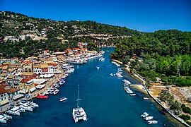
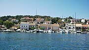
 Gaios Port | |
| Coordinates: 39°12′N 20°10′E / 39.200°N 20.167°E | |
| Country | Greece |
| Administrative region | Ionian Islands |
| Regional unit | Corfu |
| Area | |
• Municipality | 30.121 km2 (11.630 sq mi) |
| Population (2021)[1] | |
• Municipality | 2,466 |
| • Density | 82/km2 (210/sq mi) |
| Time zone | UTC+2 (EET) |
| • Summer (DST) | UTC+3 (EEST) |
| Postal code | 490 82 |
| Area code(s) | 26620 |
| Vehicle registration | KY |
| Website | www.paxi.gr |
Paxos (Greek: Παξός) is a Greek island in the Ionian Sea, lying just south of Corfu. As a group with the nearby island of Antipaxos and adjoining islets, it is also called by the plural form Paxi or Paxoi (Greek: Παξοί, pronounced /pækˈsiː/ in English and [paˈksi] in Greek). The main town and the seat of the municipality is Gaios.[2] The smallest of the seven main Ionian Islands (the Heptanese), Paxos has an area of 25.3 square kilometres (9.8 sq mi), while the municipality has an area of 30.121 km2 (11.630 sq mi)[3] and a population of about 2,500.
Paxos lies some 15 km from the southern tip of Corfu and at about the same distance from the town of Parga on the mainland. It is connected by ferry lines from Igoumenitsa and Corfu with Gaios. The island is hilly, the highest point having an elevation of 230 m.[4]
In Greek mythology, Poseidon created the island by striking Corfu with his trident, so that he and his wife Amphitrite could have some peace and quiet.
History
[edit]Paxos is a historical island that has been inhabited since prehistoric times. According to tradition, the Phoenicians were the first settlers on Paxos, and it is believed that the name "Paxos" originated from the Phoenician word "Pax," meaning "trapezoidal." In ancient times, Paxos played a significant role, especially during the First Illyrian War in 229 BC when the Battle of Paxos was fought between the ancient Greek and Illyrian fleets. The account of this battle is documented in The Histories, a work by the ancient historian Polybius.
Paxos has been ruled by various conquerors, including the Romans in the 2nd century BC, pirates during the Byzantine era and Middle Ages, and by Crusaders. Eventually, the Venetians gained control of the island at the end of the 14th century.
During the Napoleonic Wars, the Ionian Islands were occupied by the French and the Russo-Turkish alliance. However, Paxos surrendered to the Royal Navy frigate HMS Apollo and 160 troops from the 2nd Greek Light Infantry from Cephalonia and the 35th Regiment of the Royal Corsican Rangers on February 13, 1814. The United Kingdom established the Ionian Union in 1815, and in 1864, Paxos, along with the rest of the Ionian Islands, was ceded to Greece.
Geography
[edit]

Paxos lies some 15 km from the southern tip of Corfu, and at about the same distance from the town of Parga on the mainland.
The island is approximately 10 kilometres (6 mi) long and up to 3 kilometres (2 mi) wide, stretching in northwest–southeast direction. Much of the hilly landscape is covered in olive groves. These stretch from Lakka, the harbour community in the north, through Magazia to Gaios, the capital. Coastal communities of Gaios, Lakka and Longos on the east coast are the three main settlements, while the interior features numerous scattered hamlets. The west coast is dominated by steep white, chalky cliffs that are greatly eroded at sea level, and harbour many "blue caves". The highest point of the island is Agios Isavros at an elevation of 231 m. Several islets lie very close to the coast of Paxos: Agios Nikolaos and Panagia protect the harbor of Gaios, while Mongonisi and Kaltsonisi lie off the southeastern tip. Antipaxos lies some 5 km further southeast.[5]
The production of olive oil, soap manufacture and fishing were supplanted by tourism as the main industry in the mid-1960s, resulting in a construction boom, which has greatly altered the coastline around Gaios, the capital of the Paxiot demos (community).
Province
[edit]The province of Paxoi (Greek: Επαρχία Παξών) was one of the provinces of the Corfu Prefecture. Its territory corresponded with that of the current municipality Paxoi.[6] It was abolished in 2006.
Foreign residents
[edit]Among well known semi-permanent British inhabitants were Audrey Good, former commander of the UN refugee bases in Epirus following the Greek Civil War, actor Peter Bull (author of It Isn't All Greek to Me), and actress Susannah York.
Members of the Agnelli family (of FIAT fame) have built a palatial holiday home—complete with faux medieval tower—on a small island of (Kaltonisi) situated near the southernmost tip ('the heel') of Paxos, close to the beach of Mongonissi.
Paxos is part of a European network called Cultural Village of Europe. The annual Paxos Festival was founded by John Gough, and is now organised by the Guildhall School of Music and Drama in London, and attracts some of Europe's finest young performers. This festival events usually take place between June and September and are usually held in the disused school of Longos.[7]
Transport
[edit]The island is serviced by combined passenger and vehicle ferries which operate year-round from the port of Igoumenitsa on the mainland of Greece (1.5 hours). In the tourist season hydrofoils, passenger ferries and sea-taxis operate from Corfu (1–2 hours). A hydrofoil passenger service operates outside the tourist season, but is infrequent and weather dependent. Winter visitors should anticipate occasional periods of isolation.
Climate
[edit]| Climate data for Loggos, Paxi (Λογγός, Παξοί) | |||||||||||||
|---|---|---|---|---|---|---|---|---|---|---|---|---|---|
| Month | Jan | Feb | Mar | Apr | May | Jun | Jul | Aug | Sep | Oct | Nov | Dec | Year |
| Mean daily maximum °C (°F) | 13.9 (57.0) |
14.3 (57.7) |
16.0 (60.8) |
19.0 (66.2) |
23.9 (75.0) |
28.2 (82.8) |
31.1 (88.0) |
31.4 (88.5) |
27.6 (81.7) |
23.2 (73.8) |
18.5 (65.3) |
15.2 (59.4) |
21.9 (71.4) |
| Mean daily minimum °C (°F) | 5.2 (41.4) |
5.8 (42.4) |
6.8 (44.2) |
9.5 (49.1) |
13.4 (56.1) |
16.9 (62.4) |
18.8 (65.8) |
19.3 (66.7) |
16.8 (62.2) |
13.8 (56.8) |
9.8 (49.6) |
6.7 (44.1) |
11.9 (53.4) |
| Average precipitation mm (inches) | 132 (5.2) |
136 (5.4) |
98 (3.9) |
62 (2.4) |
36 (1.4) |
14 (0.6) |
7 (0.3) |
18 (0.7) |
75 (3.0) |
148 (5.8) |
181 (7.1) |
180 (7.1) |
1,087 (42.9) |
| Source: Norwegian Meteorological Institute (temperatures)[8] and Holiday Weather.com (rainfall)[9] | |||||||||||||
Communities and settlements
[edit]- Antipaxos (nearby island)
- Mogonisi (nearby island)
- Panagia (nearby island)
- Agios Nikolaos (nearby island)
- Katsonisi (nearby island)
- Apergatika
- Argyratika
- Arvanitakeika
- Aronatika
- Dalietatika
- Gaios (seat)
- Gramatikeika
- Lakka (second-largest settlement)
- Loggos (third-largest settlement)
- Magazia
- Makratika
- Ozias
- Platanos (or Fontana / Fountana)
- Velianitatika (or Veliantatika)
- Vlachopoulatika
- Zenebissatika
-
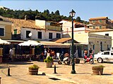
Square of Gaios
-
Museum of Paxos
-
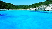
Paxi - Antipaxi coast
-
Giorgos Anemogiannis monument 1821
References
[edit]- ^ "Αποτελέσματα Απογραφής Πληθυσμού - Κατοικιών 2021, Μόνιμος Πληθυσμός κατά οικισμό" [Results of the 2021 Population - Housing Census, Permanent population by settlement] (in Greek). Hellenic Statistical Authority. 29 March 2024.
- ^ "ΦΕΚ B 1292/2010, Kallikratis reform municipalities" (in Greek). Government Gazette.
- ^ "Population & housing census 2001 (incl. area and average elevation)" (PDF) (in Greek). National Statistical Service of Greece.
- ^ "Geography of Paxi island". Greekacom. 11 May 2008. Retrieved 11 October 2022.
- ^ "Geography of Paxi island". Greekacom. 11 May 2008. Retrieved 17 October 2022.
- ^ "Detailed census results 1991" (PDF). (39 MB) (in Greek and French)
- ^ "Program 2019". Paxos Festival. Retrieved 8 September 2020.
- ^ Web: Yr – Været for Norge og verden fra NRK og Meteorologisk institutt.
- ^ Web: Holiday Weather.com


