Qian County
Qian County
乾县 | |
|---|---|
 Qianling Mausoleum complex | |
 Qian County in Xianyang | |
 Xianyang in Shaanxi | |
| Coordinates (Qian County government): 34°31′39″N 108°14′22″E / 34.5276°N 108.2394°E | |
| Country | People's Republic of China |
| Province | Shaanxi |
| Prefecture-level city | Xianyang |
| Area | |
| • Total | 1,002.71 km2 (387.15 sq mi) |
| Population (2019) | |
| • Total | 620,000 |
| • Density | 620/km2 (1,600/sq mi) |
| Time zone | UTC+8 (China standard time) |
| Postal code | 713300 |
| Licence plates | 陕D |
| Website | www |
| Qian County | |||||||
|---|---|---|---|---|---|---|---|
 "Qianxian" in Chinese characters | |||||||
| Simplified Chinese | 乾县 | ||||||
| Traditional Chinese | 乾縣 | ||||||
| |||||||
Qian County (乾县; Qián Xiàn) or Qianxian is a county under the administration of the prefecture-level city of Xianyang, in the central part of Shaanxi province, China.
Administrative divisions
[edit]Qian County is divided into 1 subdistrict and 15 towns,[1][2][3] which are further divided into 173 administrative villages.[3] The county's administrative officers are located in Chengguan Subdistrict.[2]
| Zoning Code[1] | English Name | Hanzi | Pinyin | Administrative Villages[3] |
|---|---|---|---|---|
| 610424001000 | Chengguan Subdistrict | 城关街道 | Chéngguān Jiēdào | 28 |
| 610424101000 | Xuelu Town | 薛录镇 | Xuēlù Zhèn | 14 |
| 610424102000 | Liangcun Town | 梁村镇 | Liángcūn Zhèn | 13 |
| 610424103000 | Linping Town | 临平镇 | Línpíng Zhèn | 14 |
| 610424104000 | Jiangcun Town | 姜村镇 | Jiāngcūn Zhèn | 8 |
| 610424105000 | Wangcun Town | 王村镇 | Wángcūn Zhèn | 8 |
| 610424106000 | Malian Town | 马连镇 | Mǎlián Zhèn | 8 |
| 610424107000 | Yangyu Town | 阳峪镇 | Yángyù Zhèn | 11 |
| 610424108000 | Fengyang Town | 峰阳镇 | Fēngyáng Zhèn | 7 |
| 610424109000 | Zhugan Town | 注泔镇 | Zhùgān Zhèn | 9 |
| 610424110000 | Lingyuan Town | 灵源镇 | Língyuán Zhèn | 7 |
| 610424111000 | Yanghong Town | 阳洪镇 | Yánghóng Zhèn | 8 |
| 610424112000 | Liangshan Town | 梁山镇 | Liángshān Zhèn | 10 |
| 610424113000 | Zhuocheng Town | 周城镇 | Zhōuchéng Zhèn | 7 |
| 610424114000 | Xinyang Town | 新阳镇 | Xīnyáng Zhèn | 8 |
| 610424115000 | Dayang Town | 大杨镇 | Dàyáng Zhèn | 13 |
Geography
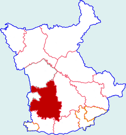
[edit]The county is bordered by Liquan County to the east, Xingping City and Wugong County to the south, Fufeng County to the west, Yongshou County to the north and west, and Linyou County to the west.[2] The northern portion of Qian County is higher in altitude than the southern portion.[2][4]
Climate
[edit]Qian County has an average annual precipitation of 539 mm, and an average annual temperature of 12.6 °C.[2]
| Climate data for Qianxian, elevation 637 m (2,090 ft), (1991–2020 normals, extremes 1981–2010) | |||||||||||||
|---|---|---|---|---|---|---|---|---|---|---|---|---|---|
| Month | Jan | Feb | Mar | Apr | May | Jun | Jul | Aug | Sep | Oct | Nov | Dec | Year |
| Record high °C (°F) | 16.5 (61.7) |
22.9 (73.2) |
29.4 (84.9) |
34.2 (93.6) |
36.6 (97.9) |
40.3 (104.5) |
39.3 (102.7) |
38.3 (100.9) |
37.3 (99.1) |
30.8 (87.4) |
24.6 (76.3) |
23.0 (73.4) |
40.3 (104.5) |
| Mean daily maximum °C (°F) | 4.8 (40.6) |
8.8 (47.8) |
14.7 (58.5) |
21.2 (70.2) |
25.9 (78.6) |
30.6 (87.1) |
31.8 (89.2) |
29.6 (85.3) |
24.4 (75.9) |
18.7 (65.7) |
12.4 (54.3) |
6.5 (43.7) |
19.1 (66.4) |
| Daily mean °C (°F) | −0.8 (30.6) |
2.9 (37.2) |
8.5 (47.3) |
14.6 (58.3) |
19.7 (67.5) |
24.6 (76.3) |
26.4 (79.5) |
24.6 (76.3) |
19.5 (67.1) |
13.4 (56.1) |
6.6 (43.9) |
0.8 (33.4) |
13.4 (56.1) |
| Mean daily minimum °C (°F) | −4.8 (23.4) |
−1.4 (29.5) |
3.6 (38.5) |
8.9 (48.0) |
13.6 (56.5) |
18.6 (65.5) |
21.5 (70.7) |
20.4 (68.7) |
15.6 (60.1) |
9.5 (49.1) |
2.3 (36.1) |
−3.4 (25.9) |
8.7 (47.7) |
| Record low °C (°F) | −14.3 (6.3) |
−11.3 (11.7) |
−7.7 (18.1) |
−1.8 (28.8) |
2.3 (36.1) |
8.3 (46.9) |
14.1 (57.4) |
12.6 (54.7) |
6.7 (44.1) |
−3.5 (25.7) |
−8.5 (16.7) |
−15.8 (3.6) |
−15.8 (3.6) |
| Average precipitation mm (inches) | 6.8 (0.27) |
8.9 (0.35) |
21.6 (0.85) |
35.3 (1.39) |
46.6 (1.83) |
61.6 (2.43) |
88.3 (3.48) |
91.2 (3.59) |
90.6 (3.57) |
49.2 (1.94) |
17.1 (0.67) |
4.4 (0.17) |
521.6 (20.54) |
| Average precipitation days (≥ 0.1 mm) | 3.9 | 4.2 | 6.2 | 6.7 | 9.4 | 8.5 | 10.0 | 10.0 | 11.1 | 10.0 | 5.3 | 2.8 | 88.1 |
| Average snowy days | 4.7 | 3.8 | 1.7 | 0.1 | 0 | 0 | 0 | 0 | 0 | 0 | 1.4 | 3.1 | 14.8 |
| Average relative humidity (%) | 59 | 60 | 60 | 62 | 62 | 60 | 68 | 74 | 77 | 75 | 69 | 60 | 66 |
| Mean monthly sunshine hours | 147.2 | 143.1 | 168.4 | 191.0 | 210.4 | 207.2 | 214.4 | 185.7 | 142.1 | 136.6 | 150.8 | 150.7 | 2,047.6 |
| Percent possible sunshine | 47 | 46 | 45 | 49 | 49 | 48 | 49 | 45 | 39 | 39 | 49 | 50 | 46 |
| Source: China Meteorological Administration[5][6] | |||||||||||||
History
[edit]Neolithic Age
[edit]Qianling County's history can be traced as far back as the Neolithic Age, due to two archaeological studies which uncovered the ruins of Neolithic settlements.[7] These digs uncovered a variety of human tools, such as stone axes and pottery.[7] The uncovered village ruins sat at the confluence of two rivers, and exhibited evidence which suggests that these villagers were well-versed in both agriculture and animal husbandry.[7]
Tang dynasty
[edit]The county's name derives from the Tang settlement of Qianzhou [zh], which was established in present-day Qian County in 895 CE.[7]
People's Republic of China
[edit]The county came under control of the People's Republic of China in 1949, and was incorporated as part of the Shaan-Gan-Ning Border Region until its dissolution one year later.[7] The area's jurisdiction would be further altered in 1956, 1959, 1961, 1968, and 1984.[7]
During Mao Zedong's Down to the Countryside Movement, famous director Zhang Yimou was sent to Qian County, where he worked as a farmer and painter.[8]
Historical monuments
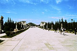
[edit]A Tang dynasty imperial tomb complex, Qianling Mausoleum is located on Liang Mountain (梁山) in Qian County, 6 km (3.7 mi) away from the county's urban center and 74 km (46 mi)from Xi'an.[9]
Economy
[edit]The county recorded a GDP of 17.16 billion Renminbi, a 0.9% increase from the previous year.[4] The average annual disposable income for urban residents was 35,485 Renminbi in 2019, and was 12,114 Renminbi for rural residents, an annual growth of 8.5% and 9.4%, respectively.[4]
Agriculture
[edit]Key crops for the county include wheat, corn, rapeseed, apples, pears, peaches, grapes, and persimmons.[4] Common livestock include pigs, cows, and goats.[4]
Industry
[edit]The county has three major industrial parks, one producing auto parts, another producing textiles, and the other producing food and drug products.[4]
Culture
[edit]Qian County's local cuisine has a number of distinct local dishes, such as a unique type of tofu soup,[10] and a type of fried cake.[11]
Transport
[edit]A number of highways pass through the county, including China National Highway 312, the G70 Expressway, Shaanxi Provincial Road 107, and Shaanxi Provincial Road 108.[4]
A number of railways, such as the Yinchuan-Xi'an High Speed Railway, the Xi'an-Pingliang Railway [zh], and the Xi'an-Famen Railway pass through the city.[4]
References
[edit]- ^ a b 2017年统计用区划代码 (in Chinese (China)). National Bureau of Statistics of the People's Republic of China. Retrieved 2020-05-01.
- ^ a b c d e 乾县概况地图_行政区划网(区划地名网) www.xzqh.org (in Chinese (China)). XZQH.org. Retrieved 2020-05-01.
- ^ a b c 乾县行政区划_乾县人民政府 (in Chinese (China)). Qian County People's Government. Retrieved 2020-05-01.
- ^ a b c d e f g h 乾县概况_乾县人民政府 (in Chinese (China)). Qian County People's Government. Retrieved 2020-05-01.
- ^ 中国气象数据网 – WeatherBk Data (in Simplified Chinese). China Meteorological Administration. Retrieved 26 August 2023.
- ^ 中国气象数据网 (in Simplified Chinese). China Meteorological Administration. Retrieved 26 August 2023.
- ^ a b c d e f 乾县历史沿革_乾县人民政府 (in Chinese (China)). Qian County People's Government. Retrieved 2020-05-01.
- ^ "President Xi Jinping and other sent-down youths who are now big names in China". The Straits Times. 2016-05-15. Retrieved 2020-05-01.
- ^ 乾陵无字碑之谜 [The riddle of a blank stele at Qianling] (in Simplified Chinese).
- ^ 乾州豆腐汤_乾县人民政府 (in Chinese (China)). Qian County People's Government. Retrieved 2020-05-01.
- ^ 【乾县小吃】油糕_乾县人民政府 (in Chinese (China)). Qian County People's Government. Retrieved 2020-05-01.
