Naga, Cebu: Difference between revisions
Undid revision 1239800920 by Chipmunkdavis (talk) |
m Reverted edit by 119.18.113.202 (talk) to last version by Chipmunkdavis |
||
| Line 142: | Line 142: | ||
| blank_info_sec1 = {{PH wikidata|climate_type}} |
| blank_info_sec1 = {{PH wikidata|climate_type}} |
||
| blank1_name_sec1 = [[Languages of the Philippines|Native languages]] |
| blank1_name_sec1 = [[Languages of the Philippines|Native languages]] |
||
| blank1_info_sec1 = |
| blank1_info_sec1 = {{PH wikidata|language}} |
||
| blank2_name_sec1 = [[Crime index]] |
| blank2_name_sec1 = [[Crime index]] |
||
| blank2_info_sec1 = |
| blank2_info_sec1 = |
||
| Line 173: | Line 173: | ||
}} |
}} |
||
'''Naga''', officially the '''City of Naga''' ({{lang-ceb|Dakbayan sa Naga}}), is a 3rd class [[Cities of the Philippines#Legal classification|component city]] in the [[Provinces of the Philippines|province]] of [[Cebu]], [[Philippines]]. According to the 2020 census, it has a population of 133,184 people.{{PH census|current}} |
'''Naga''', officially the '''City of Naga''' ({{lang-ceb|Dakbayan sa Naga}}; {{lang-fil|Lungsod ng Naga}}), is a 3rd class [[Cities of the Philippines#Legal classification|component city]] in the [[Provinces of the Philippines|province]] of [[Cebu]], [[Philippines]]. According to the 2020 census, it has a population of 133,184 people.{{PH census|current}} |
||
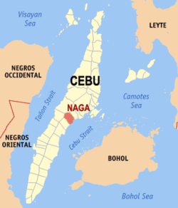
Naga City is bordered to the north by the town of [[Minglanilla, Cebu|Minglanilla]], to the west is the city of [[Toledo City, Cebu|Toledo]], to the east is the [[Cebu Strait]], and to the south is the town of [[San Fernando, Cebu|San Fernando]]. It is {{convert|21|km}} from [[Cebu City]]. |
Naga City is bordered to the north by the town of [[Minglanilla, Cebu|Minglanilla]], to the west is the city of [[Toledo City, Cebu|Toledo]], to the east is the [[Cebu Strait]], and to the south is the town of [[San Fernando, Cebu|San Fernando]]. It is {{convert|21|km}} from [[Cebu City]]. |
||
Revision as of 18:19, 11 August 2024
Naga | |
|---|---|
| City of Naga | |
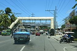
 Highway in Naga | |
| Nickname: The Industrial Hub of Southern Cebu[1] | |
| Motto(s): Naga atong garbo Service with a Heart | |
| Anthem: Mahal Kong Naga (My Beloved Naga) | |
 Map of Cebu with Naga highlighted | |
Location within the Philippines | |
| Coordinates: 10°13′N 123°45′E / 10.22°N 123.75°E | |
| Country | Philippines |
| Region | Central Visayas |
| Province | Cebu |
| District | 1st district |
| Founded | 1785 |
| Cityhood | September 2, 2007 (Lost cityhood in 2008 and 2010) |
| Affirmed Cityhood | February 15, 2011 |
| Barangays | 28 (see Barangays) |
| Government | |
| • Type | Sangguniang Panlungsod |
| • Mayor | Valdemar M. Chiong (NP) |
| • Vice Mayor | Virgilio M. Chiong (NP) |
| • Representative | Rhea Mae A. Gullas |
| • City Council | Members |
| • Electorate | 82,753 voters (2022) |
| Area | |
| • Total | 101.97 km2 (39.37 sq mi) |
| Elevation | 105 m (344 ft) |
| Highest elevation | 819 m (2,687 ft) |
| Lowest elevation | 0 m (0 ft) |
| Population (2020 census)[4] | |
| • Total | 133,184 |
| • Density | 1,300/km2 (3,400/sq mi) |
| • Households | 32,011 |
| Economy | |
| • Income class | 5th city income class |
| • Poverty incidence | 26.02 |
| • Revenue | ₱ 856.6 million (2020) |
| • Assets | ₱ 3,975 million (2020) |
| • Expenditure | ₱ 942.1 million (2020) |
| • Liabilities | ₱ 1,314 million (2020) |
| Service provider | |
| • Electricity | Visayan Electric Company (VECO) |
| Time zone | UTC+8 (PST) |
| ZIP code | 6037 |
| PSGC | |
| IDD : area code | +63 (0)32 |
| Native languages | Cebuano Tagalog |
| Website | www |
Naga, officially the City of Naga (Template:Lang-ceb; Template:Lang-fil), is a 3rd class component city in the province of Cebu, Philippines. According to the 2020 census, it has a population of 133,184 people.[4]
Naga City is bordered to the north by the town of Minglanilla, to the west is the city of Toledo, to the east is the Cebu Strait, and to the south is the town of San Fernando. It is 21 kilometres (13 mi) from Cebu City.
It lies within the Cebu metropolitan area.[6]
It is one of the two Philippine cities named Naga, the other being Naga, Camarines Sur in Luzon.
History
Naga was previously named by the first settlers as "Narra" due to the abundance of trees called "narra". The name eventually became to what is now known as "Naga". Naga became a municipality on June 12, 1829.
Cityhood
Cityhood was ratified in a plebiscite on September 2, 2007. The Supreme Court declared the cityhood law of Naga and 15 other cities unconstitutional after a petition filed by the League of Cities of the Philippines in its ruling on November 18, 2008. On December 22, 2009, the cityhood law of Naga and 15 other municipalities regain its status as cities again after the court reversed its ruling November 18, 2008 ruling.
On August 23, 2010, the court reinstated its ruling on November 18, 2008, making Naga and 15 other cities regular municipalities. Finally, on February 15, 2011, Naga and the other 15 municipalities declared that the conversion to cityhood met all legal requirements. In 2013, after six years of legal battle, in its board resolution the League of Cities of the Philippines acknowledged and recognized the cityhood of Naga and 15 other cities on July 19, 2013.[7][8]
Geography
Barangays
Naga is politically subdivided into 28 barangays. Each barangay consists of puroks and some have sitios.
| PSGC | Barangay | Population | ±% p.a. | |||
|---|---|---|---|---|---|---|
| 2020[4] | 2010[9] | |||||
| 0772234001 | Alpaco | 2.6% | 3,486 | 2,921 | 1.78% | |
| 0772234002 | Bairan | 1.6% | 2,173 | 1,772 | 2.06% | |
| 0772234003 | Balirong | 3.6% | 4,760 | 3,918 | 1.97% | |
| 0772234004 | Cabungahan | 1.0% | 1,306 | 1,176 | 1.05% | |
| 0772234005 | Cantao‑an | 4.4% | 5,889 | 5,133 | 1.38% | |
| 0772234006 | Central Poblacion | 0.7% | 896 | 933 | −0.40% | |
| 0772234007 | Cogon | 3.2% | 4,267 | 3,583 | 1.76% | |
| 0772234008 | Colon | 3.4% | 4,467 | 4,227 | 0.55% | |
| 0772234009 | East Poblacion | 0.5% | 636 | 544 | 1.57% | |
| 0772234011 | Inayagan | 6.3% | 8,342 | 7,832 | 0.63% | |
| 0772234010 | Inoburan | 4.5% | 6,054 | 5,104 | 1.72% | |
| 0772234012 | Jaguimit | 1.8% | 2,344 | 2,071 | 1.25% | |
| 0772234013 | Lanas | 2.2% | 2,890 | 2,374 | 1.99% | |
| 0772234014 | Langtad | 4.7% | 6,220 | 6,900 | −1.03% | |
| 0772234015 | Lutac | 3.5% | 4,603 | 3,879 | 1.73% | |
| 0772234016 | Mainit | 2.1% | 2,770 | 2,695 | 0.27% | |
| 0772234017 | Mayana | 1.0% | 1,299 | 1,295 | 0.03% | |
| 0772234018 | Naalad | 2.2% | 2,937 | 2,700 | 0.84% | |
| 0772234019 | North Poblacion | 2.3% | 3,019 | 2,866 | 0.52% | |
| 0772234020 | Pangdan | 3.6% | 4,730 | 4,643 | 0.19% | |
| 0772234021 | Patag | 1.1% | 1,419 | 1,167 | 1.97% | |
| 0772234022 | South Poblacion | 4.3% | 5,673 | 4,459 | 2.44% | |
| 0772234023 | Tagjaguimit | 1.7% | 2,317 | 2,302 | 0.06% | |
| 0772234024 | Tangke | 4.0% | 5,263 | 4,652 | 1.24% | |
| 0772234025 | Tinaan | 5.4% | 7,157 | 4,129 | 5.65% | |
| 0772234027 | Tuyan | 8.5% | 11,337 | 10,705 | 0.58% | |
| 0772234028 | Uling | 4.6% | 6,187 | 4,470 | 3.30% | |
| 0772234029 | West Poblacion | 2.5% | 3,309 | 3,121 | 0.59% | |
| Total | 133,184 | 101,571 | 2.75% | |||
Climate
| Climate data for Naga, Cebu | |||||||||||||
|---|---|---|---|---|---|---|---|---|---|---|---|---|---|
| Month | Jan | Feb | Mar | Apr | May | Jun | Jul | Aug | Sep | Oct | Nov | Dec | Year |
| Mean daily maximum °C (°F) | 28 (82) |
29 (84) |
30 (86) |
31 (88) |
31 (88) |
30 (86) |
30 (86) |
30 (86) |
30 (86) |
29 (84) |
29 (84) |
28 (82) |
30 (85) |
| Mean daily minimum °C (°F) | 23 (73) |
23 (73) |
23 (73) |
24 (75) |
25 (77) |
25 (77) |
25 (77) |
25 (77) |
25 (77) |
25 (77) |
24 (75) |
23 (73) |
24 (75) |
| Average precipitation mm (inches) | 70 (2.8) |
49 (1.9) |
62 (2.4) |
78 (3.1) |
138 (5.4) |
201 (7.9) |
192 (7.6) |
185 (7.3) |
192 (7.6) |
205 (8.1) |
156 (6.1) |
111 (4.4) |
1,639 (64.6) |
| Average rainy days | 13.4 | 10.6 | 13.1 | 14.5 | 24.2 | 27.9 | 28.4 | 27.7 | 27.1 | 27.4 | 22.5 | 15.9 | 252.7 |
| Source: Meteoblue[10] | |||||||||||||
Demographics


| Year | Pop. | ±% p.a. |
|---|---|---|
| 1903 | 16,884 | — |
| 1918 | 21,166 | +1.52% |
| 1939 | 25,850 | +0.96% |
| 1948 | 24,911 | −0.41% |
| 1960 | 32,475 | +2.23% |
| 1970 | 35,043 | +0.76% |
| 1975 | 38,242 | +1.77% |
| 1980 | 45,831 | +3.69% |
| 1990 | 60,425 | +2.80% |
| 1995 | 69,010 | +2.52% |
| 2000 | 80,189 | +3.27% |
| 2007 | 95,163 | +2.39% |
| 2010 | 101,571 | +2.40% |
| 2015 | 115,750 | +2.52% |
| 2020 | 133,184 | +2.80% |
| Source: Philippine Statistics Authority[11][9][12][13] | ||
Economy
Poverty incidence of Naga
10
20
30
40
2006
31.40 2009
27.10 2012
17.23 2015
21.12 2018
15.30 2021
26.02 Source: Philippine Statistics Authority[14][15][16][17][18][19][20][21] |
Naga is home to several heavy industries, and as such, the city bills itself as the Industrial City of the South. Among the industries in Naga are the Apo Cement Corporation, the largest factory in the country, producing 4,000 metric tons (3,900 long tons) per day; FSP Group; the 290-megawatt KEPCO Philippines Corporation power plant; MRC Allied Industries; Pryce Gases, Inc.; Rikio Southeast Asia; the 147-megawatt coal-fired Salcon Power Corporation plant;[1] Asian Grains Corporation, a flour milling company; Sugbo ACS Food Manufacturing Corporation, the maker of Ichipan bread; UNAHCO Feeds, Inc.; and Provera Nutritional Solutions Corp. (feedmill), among other industries.
The Naga Valley Industrial Park (NAVA) is a 36 ha (89 acres) Philippine Economic Zone Authority (PEZA)-registered industrial park in Barangay Cantao-an. Locators in NAVA include Cebu Mitsumi, Inc., Kyocera Kinseki Philippines, Inc., and Tokyo Microshaft Corporation. The industrial park was a part of the 250 ha (620 acres) New Cebu Township One (NCTO) of MRC Allied before it was acquired by Cebu City-based developer Primary Properties Corporation.[22]
Sports venues
In December 2015, the Naga City government officially opened the Teodoro Mendiola Sports Field and Oval, located along North Poblacion. Its inauguration was in time for its usage as the main venue for the 2016 Central Visayas Regional Athletic Association (CVIRAA) games in February. The ₱68 million project comprises a track and field oval, swimming pool (Olympic-sized), and basketball, tennis, and volleyball courts.[23]
2017 the first time a host became back-in-back in the venue for the CVIRAA again.[24]
References
- ^ a b Philippine Global 2012.
- ^ City of Naga | (DILG)
- ^ "2015 Census of Population, Report No. 3 – Population, Land Area, and Population Density" (PDF). Philippine Statistics Authority. Quezon City, Philippines. August 2016. ISSN 0117-1453. Archived (PDF) from the original on May 25, 2021. Retrieved July 16, 2021.
- ^ a b c Census of Population (2020). "Region VII (Central Visayas)". Total Population by Province, City, Municipality and Barangay. Philippine Statistics Authority. Retrieved July 8, 2021.
- ^ "PSA Releases the 2021 City and Municipal Level Poverty Estimates". Philippine Statistics Authority. April 2, 2024. Retrieved April 28, 2024.
- ^ sparksph (March 8, 2022). "Pasilong sa Naga: Boardwalk in Naga City". Suroy.ph. Retrieved July 20, 2022.
- ^ "16 new cities recognized as LCP members (Archived)". Sun Star News. July 19, 2013. Retrieved March 6, 2018.
- ^ "League finally recognizes 16 'unqualified' cities". Rappler. July 19, 2013. Retrieved March 6, 2018.
- ^ a b Census of Population and Housing (2010). "Region VII (Central Visayas)" (PDF). Total Population by Province, City, Municipality and Barangay. National Statistics Office. Retrieved June 29, 2016.
- ^ "Naga City: Average Temperatures and Rainfall". Meteoblue. Retrieved May 10, 2020.
- ^ Census of Population (2015). "Region VII (Central Visayas)". Total Population by Province, City, Municipality and Barangay. Philippine Statistics Authority. Retrieved June 20, 2016.
- ^ Censuses of Population (1903–2007). "Region VII (Central Visayas)". Table 1. Population Enumerated in Various Censuses by Province/Highly Urbanized City: 1903 to 2007. National Statistics Office.
- ^ "Province of Cebu". Municipality Population Data. Local Water Utilities Administration Research Division. Retrieved December 17, 2016.
- ^ "Poverty incidence (PI):". Philippine Statistics Authority. Retrieved December 28, 2020.
- ^ "Estimation of Local Poverty in the Philippines" (PDF). Philippine Statistics Authority. November 29, 2005.
- ^ "2003 City and Municipal Level Poverty Estimates" (PDF). Philippine Statistics Authority. March 23, 2009.
- ^ "City and Municipal Level Poverty Estimates; 2006 and 2009" (PDF). Philippine Statistics Authority. August 3, 2012.
- ^ "2012 Municipal and City Level Poverty Estimates" (PDF). Philippine Statistics Authority. May 31, 2016.
- ^ "Municipal and City Level Small Area Poverty Estimates; 2009, 2012 and 2015". Philippine Statistics Authority. July 10, 2019.
- ^ "PSA Releases the 2018 Municipal and City Level Poverty Estimates". Philippine Statistics Authority. December 15, 2021. Retrieved January 22, 2022.
- ^ "PSA Releases the 2021 City and Municipal Level Poverty Estimates". Philippine Statistics Authority. April 2, 2024. Retrieved April 28, 2024.
- ^ "'Renewed interest' in Naga industrial park". SunStar Cebu. August 2, 2015. Retrieved January 8, 2023.
- ^ Sun.Star 2015.
- ^ Sun.Star 2017.
Sources
- Philippine Global, Bernard Supetran (June 25, 2012). "Economic boom brings prosperity to Cebu's new cities". Archived from the original on December 22, 2015.
- Sun.Star, Justin K. Vestil (December 14, 2015). "Naga opens P152.5M in infra, including track for runners". Archived from the original on December 14, 2015.
- Sun.Star, Richiel S. Chavez (February 11, 2017). "2017 Cviraa goes full swing today". Archived from the original on March 10, 2017.


