Capaccio Paestum
You can help expand this article with text translated from the corresponding article in Italian. (January 2022) Click [show] for important translation instructions.
|
Capaccio Paestum | |
|---|---|
| Comune di Capaccio Paestum | |
 The Sanctuary of St. Mary of Granato | |
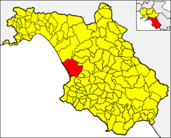
 Capaccio Paestum within the Province of Salerno | |
| Coordinates: 40°25′N 15°5′E / 40.417°N 15.083°E | |
| Country | Italy |
| Region | Campania |
| Province | Salerno (SA) |
| Frazioni | Borgo Nuovo, Cafasso, Capaccio Scalo, Chiorbo, Foce Sele, Gaiarda, Gromola, Laura, Licinella, Linora, Paestum, Ponte Barizzo, Rettifilo-Vannulo, Spinazzo, Santa Venere, Tempa di Lepre, Torre di Mare, Tempa San Paolo, Vuccolo Maiorano |
| Government | |
| • Mayor | Franco Palumbo |
| Area | |
| • Total | 113.03 km2 (43.64 sq mi) |
| Elevation | 441 m (1,447 ft) |
| Population (31 December 2017)[2] | |
| • Total | 22,802 |
| • Density | 200/km2 (520/sq mi) |
| Demonym | Capaccesi |
| Time zone | UTC+1 (CET) |
| • Summer (DST) | UTC+2 (CEST) |
| Postal code | 84047 (Capoluogo), 84040 (Capaccio Scalo), 84050 (Laura-Gromola), 84063 ( Paestum), 84060 (Ponte Barizzo) |
| Dialing code | 0828 |
| Patron saint | St. Vitus |
| Saint day | 15 June |
| Website | Official website |
Capaccio Paestum (formerly only Capaccio, from Latin Caput Aquae) is a town and comune in the province of Salerno in the Campania region of south-western Italy. The ruins of the ancient Greek city of Paestum lie within borders of the comune.
History
[edit]This section needs expansion. You can help by adding to it. (May 2010) |
Geography
[edit]Located in northern Cilento, near the mouth of Sele, Capaccio is a hill town surrounded by a plain in which resides almost all of the hamlets (frazioni) and the majority of the population, mostly concentrated at Capaccio Scalo, seat of the train station.
The municipality borders with Agropoli, Albanella, Cicerale, Eboli, Giungano, Roccadaspide and Trentinara. The hamlets are Borgo Nuovo, Capaccio Scalo, Cafasso, Chiorbo, Foce Sele, Gaiarda, Gromola, Laura, Licinella, Linora, Paestum, Ponte Barizzo, Rettifilo-Vannulo, Spinazzo, Santa Venere, Tempa di Lepre, Torre di Mare, Tempa San Paolo, and Vuccolo Maiorano.[3]
Transport
[edit]The nearest airport is Salerno-Pontecagnano (QSR), 35 km from Capaccio.
Notable people
[edit]See also
[edit]Notes and references
[edit]- ^ "Superficie di Comuni Province e Regioni italiane al 9 ottobre 2011". Italian National Institute of Statistics. Retrieved 16 March 2019.
- ^ (in Italian) Source: Istat 2011
- ^ 40478 Capaccio on OpenStreetMap
External links
[edit]


