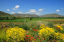
Akşar, Bayburt
Appearance
Akşar | |
|---|---|
| Coordinates: 40°21′03″N 39°58′26″E / 40.3507°N 39.9740°E | |
| Country | Turkey |
| Province | Bayburt |
| District | Bayburt |
| Population (2021) | 512 |
| Time zone | UTC+3 (TRT) |

Akşar is a village in the Bayburt District, Bayburt Province, Turkey.[1] Its population is 512 (2021).[2] Before the 2013 reorganisation, it was a town (belde).[3]
History
[edit]The former name of the village was Balahor.[4]
References
[edit]- ^ Köy, Turkey Civil Administration Departments Inventory. Retrieved 30 January 2023.
- ^ "Address-based population registration system (ADNKS) results dated 31 December 2021" (XLS) (in Turkish). TÜİK. Retrieved 30 January 2023.
- ^ Law No. 6360, Official Gazette, 6 December 2012 (in Turkish).
- ^ Köylerimiz: 1 Mart 1968 gününe kadar (in Turkish). Ankara, Türkiye: İçişleri Bakanlığı İller İdaresi Genel Müdürlüğü. 1968. p. 28. Archived from the original on 23 February 2020.
{{cite book}}: CS1 maint: date and year (link)

