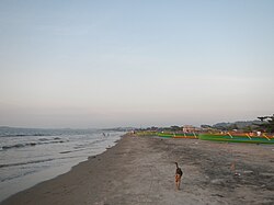
Bauang
Penampilan
Bauang | |
|---|---|
 | |
 Peta La Union dengan Bauang dipaparkan | |
 | |
Lokasi di Filipina | |
| Koordinat: 16°32′N 120°20′E / 16.53°N 120.33°EKoordinat: 16°32′N 120°20′E / 16.53°N 120.33°E | |
| Negara | Filipina |
| Daerah | Daerah Ilocos (Daerah I) |
| Wilayah | La Union |
| Barangay | 39 |
| Tarikh asas | 1590 |
| Pentadbiran | |
| • Pengundi | 52,808 (9 Mei 2022) |
| Keluasan | |
| • Jumlah | 73.15 km2 (28.24 batu persegi) |
| Aras | 41 m (135 ft) |
| Penduduk (1 Mei 2020) [2] | |
| • Jumlah | 78,449 |
| • Kepadatan | 1,100/km2 (2,800/batu persegi) |
| • Bilangan rumah | 19,796 |
| Ekonomi | |
| • Kelas pendapatan | pendapatan kelas pertama perbandaran |
| • Kadar kemiskinan | 7.54% (2021)[3] |
| • Hasil | ₱372,340,837.87185,422,495.36190,445,161.74226,265,788.42241,990,629.32309,741,612.92270,712,085.31387,175,743.76302,253,879.50495,654,066.48565,305,775.07 (2020) |
| • Aset | ₱1,198,633,812.91407,827,551.48403,454,333.49393,473,042.18474,432,019.37639,562,237.61742,534,260.66871,490,364.361,538,573,167.451,781,729,259.74 (2020) |
| • Liabiliti | ₱266,290,527.00178,622,225.36165,225,515.70145,952,181.21173,556,922.77153,664,641.08194,020,877.15189,589,156.27227,316,797.84396,199,901.11373,633,473.86 (2020) |
| • Perbelanjaan | ₱360,236,813.36151,876,250.88157,634,044.75197,612,906.48170,809,346.49209,624,835.79203,154,745.82249,379,640.01221,187,072.73271,927,432.48295,729,083.40 (2020) |
| Zon waktu | UTC+8 |
| Poskod | 2501 |
| PSGC | 013307000 |
| Kod kawasan | +63 (0)72 |
| Jenis iklim | Iklim monsun tropika |
| Bahasa peribumi | bahasa Iloku bahasa Tagalog |
| Laman sesawang | www |
Bauang atau lebih dikenali sebagai Perbandaran Bauang merupakan sebuah perbandaran di wilayah La Union, Filipina. Perbandaran ini mempunyai jumlah penduduk seramai 78,449 dalam isi rumah 19,796. Ia mempunyai luas 73.15 kilometer persegi dan ketinggian 41 meter di atas permukaan laut. Ia diberikan dengan kod kawasan telefon +63 (0)72 dan poskod 2501.
Barangay
[sunting | sunting sumber]- Acao
- Baccuit Norte
- Baccuit Sur
- Bagbag
- Ballay
- Bawanta
- Boy-utan
- Bucayab
- Cabalayangan
- Cabisilan
- Calumbaya
- Carmay
- Casilagan
- Central East
- Central West
- Dili
- Disso-or
- Guerrero
- Nagrebcan
- Pagdalagan Sur
- Palintucang
- Palugsi-Limmansangan
- Parian Oeste
- Parian Este
- Paringao
- Payocpoc Norte Este
- Payocpoc Norte Oeste
- Payocpoc Sur
- Pilar
- Pudoc
- Pottot
- Pugo
- Quinavite
- Lower San Agustin
- Santa Monica
- Santiago
- Taberna
- Upper San Agustin
- Urayong
Demografi
[sunting | sunting sumber]| Tahun | Pend. | ±% setiap tahun |
|---|---|---|
| 1903 | 10,032 | — |
| 1918 | 12,952 | +1.72% |
| 1939 | 16,304 | +1.10% |
| 1948 | 22,441 | +3.61% |
| 1960 | 26,142 | +1.28% |
| 1970 | 33,307 | +2.45% |
| 1975 | 37,917 | +2.63% |
| 1980 | 41,859 | +2.00% |
| 1990 | 51,573 | +2.11% |
| 1995 | 56,189 | +1.62% |
| 2000 | 63,373 | +2.61% |
| 2007 | 69,837 | +1.35% |
| 2010 | 70,735 | +0.47% |
| 2015 | 75,032 | +1.13% |
| 2020 | 78,449 | +0.88% |
| Ref: Lembaga Perangkaan Filipina [4] [5] [6] | ||
Ekonomi
[sunting | sunting sumber]| Kadar kemiskinan | |
| Ref: Lembaga Perangkaan Filipina[7][8][9][10][11][12][13][14][15] | |
Rujukan
[sunting | sunting sumber]- ^ "Province: La Union". PSGC Interactive. Bandar Quezon, Filipina: Lembaga Perangkaan Filipina. Dicapai pada 12 November 2016.
- ^ Census of Population (2020). "Region I (Ilocos Region)". Total Population by Province, City, Municipality and Barangay. PSA. Dicapai pada 8 Julai 2021.
- ^ "PSA Releases the 2021 City and Municipal Level Poverty Estimates". 2 April 2024. Dicapai pada 28 April 2024.
- ^ Census of Population (2015). "Region I (Ilocos Region)". Total Population by Province, City, Municipality and Barangay. PSA. Dicapai pada 20 Jun 2016.
- ^ Census of Population and Housing (2010). "Region I (Ilocos Region)". Total Population by Province, City, Municipality and Barangay. NSO. Dicapai pada 29 Jun 2016.
- ^ Censuses of Population (1903–2007). "Region I (Ilocos Region)". Table 1. Population Enumerated in Various Censuses by Province/Highly Urbanized City: 1903 to 2007. NSO.
- ^ "Kadar kemiskinan:". Lembaga Perangkaan Filipina. Dicapai pada 28 Disember 2020.
- ^ "Estimation of Local Poverty in the Philippines" (PDF). 29 November 2005.
- ^ "2003 City and Municipal Level Poverty Estimates" (PDF). 23 Mac 2009.
- ^ "City and Municipal Level Poverty Estimates; 2006 and 2009" (PDF). 3 Ogos 2012.
- ^ "City and Municipal Level Poverty Estimates; 2006 and 2009" (PDF). 3 Ogos 2012.
- ^ "2012 Municipal and City Level Poverty Estimates" (PDF). 31 Mei 2016.
- ^ "Municipal and City Level Small Area Poverty Estimates; 2009, 2012 and 2015". 10 Julai 2019.
- ^ "PSA Releases the 2018 Municipal and City Level Poverty Estimates". 15 Disember 2021. Dicapai pada 22 Januari 2022.
- ^ "PSA Releases the 2021 City and Municipal Level Poverty Estimates". 2 April 2024. Dicapai pada 28 April 2024.
Pautan luar
[sunting | sunting sumber]- PhilAtlas.com
- Philippine Standard Geographic Code
- Philippine Census Information
- Local Governance Performance Management System
- www
.bauangtgis .gov .ph

