El Naranjo Airport
Appearance
El Naranjo Airport | |||||||||||
|---|---|---|---|---|---|---|---|---|---|---|---|
| Summary | |||||||||||
| Airport type | Public | ||||||||||
| Serves | Masagua, Guatemala | ||||||||||
| Elevation AMSL | 140 ft / 43 m | ||||||||||
| Coordinates | 14°06′25″N 90°49′03″W / 14.10694°N 90.81750°W | ||||||||||
| Map | |||||||||||
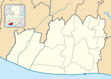
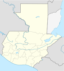
Location in Escuintla Department Location in Guatemala | |||||||||||
 | |||||||||||
| Runways | |||||||||||
| |||||||||||
El Naranjo Airport (IATA: ENJ) is a rural airstrip near El Naranjo, a settlement in the diffuse agricultural community between Masagua, Obero, and Torremolinos in Escuintla Department, Guatemala.
The San Jose VOR-DME (Ident: SJO) is located 10.5 nautical miles (19.4 km) south of the airstrip.[3]
See also
[edit]References
[edit]- ^ Google Maps - El Naranjo
- ^ Airport information for ENJ at Great Circle Mapper.
- ^ San Jose VOR
External links
[edit]- OpenStreetMap - El Naranjo Airport
- OurAirports - El Naranjo Airpport
- Accident history for El Naranjo Airport at Aviation Safety Network


