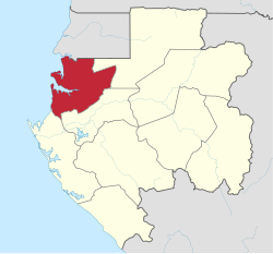
Estuaire Province
Appearance
This article needs additional citations for verification. (December 2008) |
Estuaire | |
|---|---|
| Estuaire | |
 Estuaire Province in Gabon | |
| Coordinates: 0°23′40″N 9°25′45″E / 0.39444°N 9.42917°E | |
| Country | |
| Capital | Akanda |
| Largest city | Libreville |
| Area | |
| • Total | 20,740 km2 (8,010 sq mi) |
| Population (2013 census) | |
| • Total | 895,689 |
| • Density | 43/km2 (110/sq mi) |
| HDI (2017) | 0.709[1] {.709. high |
Estuaire is the most populous of Gabon's nine provinces. It covers an area of 20,740 km2. The provincial capital is Akanda, but the largest city is Libreville, Gabon's national capital. The province is named for the Gabon Estuary, which lies at the heart of the province.
Estuaire is at the northwestern corner of Gabon, its western edge as the shores of the Gulf of Guinea. To the north, Estuaire borders the Republic of Equatorial Guinea: the Litoral Province in the northwest, and the Centro Sur Province in the northeast. Domestically, it borders the following provinces:
- Woleu-Ntem – east
- Moyen-Ogooué – south-southeast
- Ogooué-Maritime – southwest
Departments
[edit]Estuaire is divided into 5 departments:
- Komo Department (Kango)
- Komo-Mondah Department (Ntoum)
- Noya Department (Cocobeach)
- Komo-Océan Department (Ndzomoe)
- Libreville (department & Gabon's capital)
References
[edit]- ^ "Sub-national HDI - Area Database - Global Data Lab". hdi.globaldatalab.org. Retrieved 2018-09-13.


