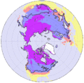
Fichier:Frozenground.gif
Apparence
Frozenground.gif (352 × 350 pixels, taille du fichier : 34 kio, type MIME : image/gif)
Historique du fichier
Cliquer sur une date et heure pour voir le fichier tel qu'il était à ce moment-là.
| Date et heure | Vignette | Dimensions | Utilisateur | Commentaire | |
|---|---|---|---|---|---|
| actuel | 19 juin 2016 à 13:02 |  | 352 × 350 (34 kio) | SteinsplitterBot | Bot: Image rotated by 270° |
| 3 juillet 2005 à 19:10 |  | 350 × 352 (33 kio) | Adam~commonswiki | Distributions of permafrost in the Northern Hemispher. *purple region : permafrost *blue regions : seasonally frozen ground (the soil is frozen for 15 days or more per year ) *pink regions : intermittently frozen ground ( the soil is frozen for fewer t | |
| 18 avril 2005 à 02:00 |  | 350 × 372 (33 kio) | Ktz~commonswiki | Distributions of permafrost in the Nortern Hemispher. {{PD-USGov-NASA}} http://earthobservatory.nasa.gov/Study/FrozenSoils/ |
Utilisation du fichier
Les 2 pages suivantes utilisent ce fichier :
Usage global du fichier
Les autres wikis suivants utilisent ce fichier :
- Utilisation sur ar.wikipedia.org
- Utilisation sur arz.wikipedia.org
- Utilisation sur ast.wikipedia.org
- Utilisation sur az.wikipedia.org
- Utilisation sur be-tarask.wikipedia.org
- Utilisation sur be.wikipedia.org
- Utilisation sur bg.wikipedia.org
- Utilisation sur bn.wikipedia.org
- Utilisation sur cdo.wikipedia.org
- Utilisation sur cv.wikipedia.org
- Utilisation sur da.wikipedia.org
- Utilisation sur en.wikipedia.org
- Utilisation sur eo.wikipedia.org
- Utilisation sur es.wikipedia.org
- Utilisation sur es.wikibooks.org
- Utilisation sur et.wikipedia.org
- Utilisation sur fi.wikipedia.org
- Utilisation sur fy.wikipedia.org
- Utilisation sur hu.wikipedia.org
- Utilisation sur hy.wikipedia.org
- Utilisation sur ilo.wikipedia.org
- Utilisation sur ja.wikipedia.org
- Utilisation sur jv.wikipedia.org
- Utilisation sur kn.wikipedia.org
- Utilisation sur la.wikipedia.org
- Utilisation sur li.wikipedia.org
- Utilisation sur lv.wikipedia.org
- Utilisation sur ms.wikipedia.org
- Utilisation sur nl.wikipedia.org
- Utilisation sur nn.wikipedia.org
- Utilisation sur no.wikipedia.org
- Utilisation sur pa.wikipedia.org
- Utilisation sur pl.wikipedia.org
- Utilisation sur pt.wikipedia.org
- Utilisation sur ru.wikipedia.org
- Utilisation sur sah.wikipedia.org
- Utilisation sur sk.wikipedia.org
- Utilisation sur sq.wikipedia.org
- Utilisation sur sr.wikipedia.org
- Utilisation sur ta.wikipedia.org
- Utilisation sur te.wikipedia.org
- Utilisation sur tr.wikipedia.org
- Utilisation sur uk.wikipedia.org
- Utilisation sur vi.wikipedia.org
- Utilisation sur wuu.wikipedia.org
- Utilisation sur zh.wikipedia.org


