File:Highway 401 cropped.png
Appearance

Size of this preview: 696 × 600 pixels. Other resolutions: 279 × 240 pixels | 557 × 480 pixels | 768 × 662 pixels.
Original file (768 × 662 pixels, file size: 1.14 MB, MIME type: image/png)
File history
Click on a date/time to view the file as it appeared at that time.
| Date/Time | Thumbnail | Dimensions | User | Comment | |
|---|---|---|---|---|---|
| current | 23:17, 3 March 2021 |  | 768 × 662 (1.14 MB) | Floydian | little shorter |
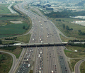
| 23:15, 3 March 2021 |  | 768 × 768 (1.32 MB) | Floydian | == {{int:filedesc}} == {{Information |Description = The 18-lane wide Highway 401 south of Toronto Pearson International Airport (YYZ) in Mississauga, Ontario. This is the widest point of the highway. |Source = Cropped version of File:Highway 401.png |Date = 2006-09-12 |Author = [https://www.flickr.com/photos/clashmaker/ Clashmaker] |Permission = |other_versions = 100px }} [[Category:Aerial photographs of Ontario Highway 401 in Mi... |
File usage
The following 2 pages use this file:
Global file usage
The following other wikis use this file:
- Usage on bn.wikipedia.org
- Usage on no.wikipedia.org
- Usage on ru.wikipedia.org

