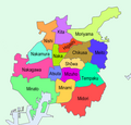
File:Nagoya Wards.png
Appearance

Size of this preview: 541 × 600 pixels. Other resolutions: 216 × 240 pixels | 433 × 480 pixels | 720 × 798 pixels.
Original file (720 × 798 pixels, file size: 127 KB, MIME type: image/png)
File history
Click on a date/time to view the file as it appeared at that time.
| Date/Time | Thumbnail | Dimensions | User | Comment | |
|---|---|---|---|---|---|
| current | 08:23, 15 August 2020 |  | 720 × 798 (127 KB) | AichiWikiFixer | New version from File:政令市区画図 23100.svg to File:Map of Aichi Prefecture.PNG They are now non-colored and new boundaries from muncipalilties and now Tempaku has been remaned "Tenpaku" and also kanji words. |
| 17:02, 22 May 2010 |  | 580 × 556 (74 KB) | Binabik | {{Information |Description={{en|Map of wards of Nagoya}} {{fr|Carte des arrondissements de Nagoya (Japon)}} {{ja|名古屋市}} |Source=http://en.wikipedia.org/wiki/File:Nagoya_Wards.png |Date={{date|6|5|2009}} |Author=*derivative work: [[:en:User:ASDFGH| |
File usage
The following page uses this file:
Global file usage
The following other wikis use this file:
- Usage on cy.wikipedia.org
- Usage on eu.wikipedia.org
- Usage on fr.wikipedia.org
- Usage on it.wikipedia.org
- Usage on ko.wikipedia.org
- Usage on ms.wikipedia.org
- Usage on my.wikipedia.org
- Usage on pt.wikipedia.org
- Usage on sv.wikipedia.org
- Usage on th.wikipedia.org
- Usage on tl.wikipedia.org
- Usage on vep.wikipedia.org
- Usage on zh-classical.wikipedia.org
