Flåm
Appearance
Flåm | |
|---|---|
Village | |
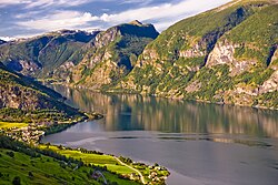
 View of Aurlandsvangen and Flåm | |
| Coordinates: 60°50′17″N 07°07′14″E / 60.83806°N 7.12056°E | |
| Country | Norway |
| Region | Western Norway |
| County | Sogn og Fjordane |
| District | Sogn |
| Municipality | Aurland |
| Elevation | 59 m (194 ft) |
| Time zone | UTC+01:00 (CET) |
| • Summer (DST) | UTC+02:00 (CEST) |
| Post Code | 5743 Flåm |
Flåm is a village in Norway. It is in the municipality of Aurland in Sogn og Fjordane county.
The closest airport is Sogndal Airport, Haukåsen, which is about 70 kilometres (43 miles) from Flåm. The European route E16 highway between Oslo and Bergen runs through Flåm.
Population
[change | change source]In 2014, the population was reported to be around 350.
References
[change | change source]- ↑ "Flåm" (in Norwegian). yr.no. Archived from the original on 9 August 2010. Retrieved 31 December 2016.
Other websites
[change | change source] Flåm travel guide from Wikivoyage
- Visit Flåm Archived 2016-12-25 at the Wayback Machine
