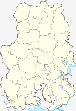
Kambarka
Kambarka
Камбарка | |
|---|---|
| Other transcription(s) | |
| • Udmurt | Камбарка |
 A monument in Kambarka to the warriors fallen in the Great Patriotic War | |
| Coordinates: 56°16′N 54°13′E / 56.267°N 54.217°E | |
| Country | Russia |
| Federal subject | Udmurtia[1] |
| Administrative district | Kambarsky District[1] |
| Town of district significance | Kambarka[1] |
| Founded | 1761–1767 |
| Town status since | 1945 |
| Elevation | 75 m (246 ft) |
| Population | |
| • Total | 11,021 |
| • Capital of | Kambarsky District,[1] town of district significance of Kambarka[1] |
| • Municipal district | Kambarsky Municipal District[3] |
| • Urban settlement | Kambarskoye Urban Settlement[3] |
| • Capital of | Kambarsky Municipal District,[3] Kambarskoye Urban Settlement[3] |
| Time zone | UTC+4 (MSK+1 |
| Postal code(s)[5] | |
| OKTMO ID | 94620101001 |
Kambarka (Russian: Камбарка) is a town and the administrative center of Kambarsky District of the Udmurt Republic, Russia, located on the Kambarka River (Kama's basin), 116 kilometers (72 mi) southeast of Izhevsk. Population: 11,021 (2010 Census);[2] 12,636 (2002 Census);[6] 13,258 (1989 Soviet census).[7]
History
[edit]It was founded as a settlement around a Demidov ironworks, which was constructed in 1761–1767.[citation needed] It was granted town status in 1945.[citation needed]
The city of Kambarka was one of the residence centers of the Udmurt Jews.[8]
Administrative and municipal status
[edit]Within the framework of administrative divisions, Kambarka serves as the administrative center of Kambarsky District.[1] As an administrative division, it is incorporated within Kambarsky District as the town of district significance of Kambarka.[1] As a municipal division, the town of district significance of Kambarka is incorporated within Kambarsky Municipal District as Kambarskoye Urban Settlement.[3]
Economy
[edit]Kambarka Engineering Works operates in the town. They mainly produce locomotives and other railway stock. Operates a chemical plant.[citation needed]
Chemical weapons destruction plant
[edit]A chemical weapons destruction plant was built in Kambarka during the Soviet times.[citation needed] This was in accordance to the obligations under the CWC to destroy all of the chemical weapon stockpiles by 2012.
International relations
[edit]Twin towns and sister cities
[edit]On May 17, 2002, Mayor Georgy Kislov signed a Sister Cities International agreement with Mayor Charlie Roberts of the city of Tooele, Utah in the United States. As of 2022, Tooele, Utah is no longer in a agreement with the City of Kambarka due to the conflict between Russia and Ukraine.
References
[edit]Notes
[edit]- ^ a b c d e f g h Law #46-RZ
- ^ a b Russian Federal State Statistics Service (2011). Всероссийская перепись населения 2010 года. Том 1 [2010 All-Russian Population Census, vol. 1]. Всероссийская перепись населения 2010 года [2010 All-Russia Population Census] (in Russian). Federal State Statistics Service.
- ^ a b c d e Law #81-ZR
- ^ "Об исчислении времени". Официальный интернет-портал правовой информации (in Russian). June 3, 2011. Retrieved January 19, 2019.
- ^ Почта России. Информационно-вычислительный центр ОАСУ РПО. (Russian Post). Поиск объектов почтовой связи (Postal Objects Search) (in Russian)
- ^ Federal State Statistics Service (May 21, 2004). Численность населения России, субъектов Российской Федерации в составе федеральных округов, районов, городских поселений, сельских населённых пунктов – районных центров и сельских населённых пунктов с населением 3 тысячи и более человек [Population of Russia, Its Federal Districts, Federal Subjects, Districts, Urban Localities, Rural Localities—Administrative Centers, and Rural Localities with Population of Over 3,000] (XLS). Всероссийская перепись населения 2002 года [All-Russia Population Census of 2002] (in Russian).
- ^ Всесоюзная перепись населения 1989 г. Численность наличного населения союзных и автономных республик, автономных областей и округов, краёв, областей, районов, городских поселений и сёл-райцентров [All Union Population Census of 1989: Present Population of Union and Autonomous Republics, Autonomous Oblasts and Okrugs, Krais, Oblasts, Districts, Urban Settlements, and Villages Serving as District Administrative Centers]. Всесоюзная перепись населения 1989 года [All-Union Population Census of 1989] (in Russian). Институт демографии Национального исследовательского университета: Высшая школа экономики [Institute of Demography at the National Research University: Higher School of Economics]. 1989 – via Demoscope Weekly.
- ^ Altyntsev A.V., "The Concept of Love in Ashkenazim of Udmurtia and Tatarstan", Nauka Udmurtii. 2013. № 4 (66), p. 131. (Алтынцев А.В., "Чувство любви в понимании евреев-ашкенази Удмуртии и Татарстана". Наука Удмуртии. 2013. №4. С. 131: Комментарии.) (in Russian)
Sources
[edit]- Государственный Совет Удмуртской Республики. Закон №46-РЗ от 19 октября 2006 г. «Об административно-территориальном устройстве Удмуртской Республики», в ред. Закона №60-РЗ от 12 октября 2012 г. «О внесении изменений в отдельные Законы Удмуртской Республики». Вступил в силу через десять дней после официального опубликования. Опубликован: "Известия Удмуртской Республики", №185, 12 декабря 2006 г. (State Council of the Udmurt Republic. Law #46-RZ of October 19, 2006 On the Administrative-Territorial Structure of the Udmurt Republic, as amended by the Law #60-RZ of October 12, 2012 On Amending Various Laws of the Udmurt Republic. Effective as of the day which is ten days after the official publication.).
- Государственный Совет Удмуртской Республики. Закон №81-РЗ от 8 декабря 2004 г. «Об установлении границ муниципальных образований и наделении соответствующим статусом муниципальных образований на территории Камбарского района Удмуртской Республики», в ред. Закона №45-РЗ от 10 сентября 2007 г. «О внесении изменений в отдельные Законы Удмуртской Республики». Вступил в силу с 1 января 2005 г.. Опубликован: "Собрание законодательства Удмуртской Республики", №5, 25 июля 2005 г. (State Council of the Udmurt Republic. Law #81-RZ of December 8, 2004 On Establishing the Borders of the Municipal Formations and Granting the Status to the Municipal Formations on the Territory of Kambarsky District of the Udmurt Republic, as amended by the Law #45-RZ of September 10, 2007 On Amending Various Laws of the Udmurt Republic. Effective as of January 1, 2005.).
External links
[edit]![]() Media related to Kambarka at Wikimedia Commons
Media related to Kambarka at Wikimedia Commons
- Official website of Kambarka (in Russian)
- Kambarka Business Directory (in Russian)


