Kollengode, Palakkad
Appearance
(Redirected from Kollengode (gram panchayat))
Kollengode
Vengunad, Ayaskarapuri (Ancient Name) | |
|---|---|
Town | |
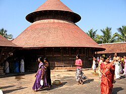
 Kachamkurissi Temple,Kollengode | |
| Nickname: Rice Bowl of Palakkad / Palace City | |
| Coordinates: 10°36′50″N 76°41′27″E / 10.61389°N 76.69083°E | |
| Country | |
| State | Kerala |
| District | Palakkad |
| Government | |
| • Body | Kollengode Panchayat |
| Area | |
• Total | 49.33 km2 (19.05 sq mi) |
| Population (2011) | |
• Total | 29,587 |
| • Density | 600/km2 (1,600/sq mi) |
| Languages | |
| • Official | Malayalam, English |
| Time zone | UTC+5:30 (IST) |
| PIN | 678506 |
| Vehicle registration | KL 70 |
Kollengode is a town in Palakkad district, Kerala, India.[1] Kollengode Town is the headquarters of Kollengode Grama Panchayat and Kollengode Block Panchayat.[citation needed]
As of 2001[update] India census, Kollengode-I had a population of 18,583 with 9,068 males and 9,515 females.[2]
Kollengode railway station is located at Oottara. State highway SH-58 passes through Kollengode. The nearest airport is Coimbatore around 70 km from Kollengode.
River
[edit]The Gayathripuzha River, a tributary of Bharathappuzha, flows near the town.
Kollengode Block Panchayat
[edit]Grama panchayats under Kollengode block panchayat are
- Kollengode
- Koduvayur
- Puthunagaram
- Vadavannur
- Muthalamada
Gallery
[edit]-
A paddy field in Kollengode
References
[edit]- ^ "പാലക്കാട് ജില്ലയിലെ ഗ്രാമ പഞ്ചായത്തുകളുടെ അടിസ്ഥാന വിവരങ്ങള് | പഞ്ചായത്ത് വകുപ്പ്". dop.lsgkerala.gov.in. Retrieved 14 October 2022.
- ^ "Census of India : Villages with population 5000 & above". Registrar General & Census Commissioner, India. Archived from the original on 8 December 2008. Retrieved 10 December 2008.
External links
[edit]Wikimedia Commons has media related to Kollengode, Palakkad.


