Krouna
Krouna | |
|---|---|
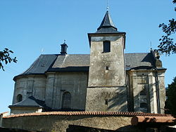
 Church of Saint Martin | |
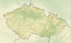
| Coordinates: 49°46′21″N 16°1′36″E / 49.77250°N 16.02667°E | |
| Country | |
| Region | Pardubice |
| District | Chrudim |
| First mentioned | 1349 |
| Area | |
• Total | 34.37 km2 (13.27 sq mi) |
| Elevation | 530 m (1,740 ft) |
| Population (2024-01-01)[1] | |
• Total | 1,425 |
| • Density | 41/km2 (110/sq mi) |
| Time zone | UTC+1 (CET) |
| • Summer (DST) | UTC+2 (CEST) |
| Postal codes | 539 01, 539 43, 539 44, 569 82 |
| Website | www |
Krouna is a municipality and village in Chrudim District in the Pardubice Region of the Czech Republic. It has about 1,400 inhabitants.
Administrative parts
[edit]The villages of Čachnov, Františky, Oldřiš, Ruda and Rychnov are administrative parts of Krouna.
Geography
[edit]Krouna is located about 25 kilometres (16 mi) southeast of Chrudim and 34 km (21 mi) southeast of Pardubice. The western part of the municipal territory lies in the Iron Mountains and the eastern part lies in the Upper Svratka Highlands. The highest point is at 735 m (2,411 ft) above sea level. The Chrudimka River originates in the woods in the southern part of the municipal territory. About two thirds of the territory lie within the Žďárské vrchy Protected Landscape Area.
History
[edit]The first written mention of Krouna is from 1349.[2]
The municipality is known for the Krouna train accident, in which 19 people died, making it one of the deadliest train crashes in Czech history.
Demographics
[edit]
|
|
| ||||||||||||||||||||||||||||||||||||||||||||||||||||||
| Source: Censuses[3][4] | ||||||||||||||||||||||||||||||||||||||||||||||||||||||||
Transport
[edit]The I/34 road (heading from Svitavy to Havlíčkův Brod and further to České Budějovice) passes through the municipality.
Krouna is located on the railway line Svitavy–Žďárec u Skutče.[5]
Sights
[edit]
The most important monument of Krouna is the Church of Saint Martin. It was built in the Baroque style in 1770–1773. It has a preserved core and tower from the 15th century.[6]
The Protestant church is a rural Historicist building with Neo-Romanesque elements. It dates from 1896.[7]
References
[edit]- ^ "Population of Municipalities – 1 January 2024". Czech Statistical Office. 2024-05-17.
- ^ "Základní informace" (in Czech). Obec Krouna. Retrieved 2021-10-18.
- ^ "Historický lexikon obcí České republiky 1869–2011" (in Czech). Czech Statistical Office. 2015-12-21.
- ^ "Population Census 2021: Population by sex". Public Database. Czech Statistical Office. 2021-03-27.
- ^ "Detail stanice Krouna" (in Czech). České dráhy. Retrieved 2023-09-25.
- ^ "Kostel sv. Michala" (in Czech). National Heritage Institute. Retrieved 2023-09-25.
- ^ "Kostel evangelický" (in Czech). National Heritage Institute. Retrieved 2023-09-25.


