Litchfield, Connecticut
Appearance
Litchfield, Connecticut | |
|---|---|
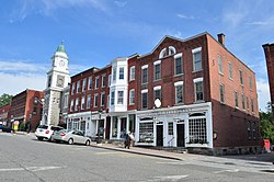
 Commercial blocks on West Street | |
| Motto(s): Unitas Sub Lege (Latin) "Unity Under the Law" | |
| Coordinates: 41°44′50″N 73°11′23″W / 41.74722°N 73.18972°W | |
| Country | |
| U.S. state | |
| County | Litchfield |
| Region | Northwest Hills |
| Incorporated | 1719[1] |
| Area | |
| • Total | 56.8 sq mi (147.1 km2) |
| • Land | 56.1 sq mi (145.3 km2) |
| • Water | 0.7 sq mi (1.8 km2) |
| Elevation | 1,080 ft (329 m) |
| Population | |
| • Total | 8,192 |
| • Density | 146/sq mi (56.4/km2) |
| Time zone | UTC-5 (EST) |
| • Summer (DST) | UTC-4 (EDT) |
| ZIP code | 06750 [Bantam], 06759 [Litchfield], 06778 [Northfield] |
| Area code(s) | 860/959 |
| FIPS code | 09-43370 |
| GNIS feature ID | 0213452 |
| Major highways | |
| Website | www |
Litchfield is a town in and former county seat of Litchfield County, Connecticut, United States.[4] The population was 8,192 at the 2020 census.[3]
References
[change | change source]- ↑ "Litchfield Connecticut". City-Data.com. Retrieved November 4, 2012.
- ↑ "2019 U.S. Gazetteer Files". United States Census Bureau. Retrieved July 2, 2020.
- ↑ 3.0 3.1 "Census - Geography Profile: Litchfield town, Litchfield County, Connecticut". United States Census Bureau. Retrieved 2021-12-17.
- ↑ "Find a County". National Association of Counties. Retrieved 2011-06-07.


