Mata, Rio Grande do Sul
Appearance
From Wikipedia, the free encyclopedia
This article needs additional citations for verification. Please help improve this article by adding citations to reliable sources. Unsourced material may be challenged and removed. Find sources: "Mata, Rio Grande do Sul" – news · newspapers · books · scholar · JSTOR (January 2021) (Learn how and when to remove this message) |
Place in South, Brazil
Mata | |
|---|---|
 | |
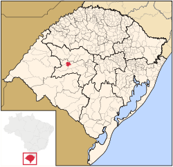
 Location in Rio Grande do Sul, Brazil | |
| Coordinates: 29°33′57″S 54°27′36″W / 29.56583°S 54.46000°W / -29.56583; -54.46000 | |
| Country | Brazil |
| Region | South |
| State | Rio Grande do Sul |
| Government | |
| • Mayor | Sergio Roni Bruning |
| Area | |
| • Total | 312.120 km2 (120.510 sq mi) |
| Elevation | 127 m (417 ft) |
| Population (2020 [1]) | |
| • Total | 4,797 |
| • Density | 15/km2 (40/sq mi) |
| Time zone | UTC−3 (BRT) |
Mata is a municipality in Rio Grande do Sul in Brazil.
Paleontology
[edit]The city of Mata has large deposits of petrified trees.
Museum of the city that have fossils:
- Museum Daniel Cargnin.
- Palaeobotanical Garden in Mata
-
Museum Daniel Cargnin
-
Petrified wood in the Paleobotanic Park
-
São Roque community
References
[edit]External links
[edit] Mata travel guide from Wikivoyage
| International | |
|---|---|
| National | |
 | This geographical article relating to Rio Grande do Sul is a stub. You can help Wikipedia by expanding it. |


