Jump to content

N3 road (Belgium)

Coordinates: 50°46′39″N 5°14′51″E / 50.77754°N 5.24751°E / 50.77754; 5.24751
From Wikipedia, the free encyclopedia
National Route 3 shield}}
National Route 3
Dutch: Nationale Weg 3
French: Route nationale 3
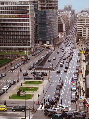
Wetstraat.jpg
The Rue de la Loi / Wetstraat in Brussels
Route information
Length136 km (85 mi)
Major junctions
FromBrussels
ToKelmis
Location
CountryBelgium
Regions
Major citiesBrussels, Leuven, Tienen, Sint-Truiden, Liège
Highway system
  • Highways of Belgium

The N3 road in Belgium is a national road connecting the capital city Brussels to Aachen in Germany via Leuven, Tienen, Sint-Truiden and Liège. Its course is quite similar to that of European route E40 between Brussels and Aachen, which it intersects 3 times. The road runs through the 3 Belgian regions (Brussels, Flanders and Wallonia) and the 3 communities (Dutch-speaking, French-speaking and German-speaking).

Starting at the small Brussels ring road crossroad Arts-Loi in the City of Brussels, the road is first named Rue de la Loi (direction Brussels centrum) or Rue Belliard (direction Aachen), then enters the Belliard tunnel under the Cinquantenaire park before it becomes the Avenue de Tervueren/Tervurenlaan past the Tervuren gate in Etterbeek. The Avenue de Tervueren then crosses the municipality of Woluwe-Saint-Pierre from the Montgomery Place, passes along the Woluwe and Parmentier parks before it joins the Chaussée de Tervueren/Tervuursesteenweg in Auderghem. Past this intersection, the N3 road comes back to Woluwe-Saint-Pierre where it crosses the Brussels Ring after which it leaves the region of Brussels for Flanders in Tervuren, Flemish Brabant.

Before it arrives to Leuven where it joins the N2 road on the Leuven Ring, the road crosses highways E40 in Bertem and E314 in Heverlee, a borough of Leuven. Between Leuven and Tienen the N3 road runs parallel to the E40 and the railroad Leuven-Tienen. Arriving in Sint-Truiden, the road enters the province of Limburg and leaves it for the Walloon province of Liège at Oreye. It intersects the E40 highway again at Loncin and then runs through the city centre of Liège and crosses the river Meuse there. Going north-east the road intersects the E40 for the 3rd time in Soumagne. The N3 finally crosses 2 municipalities of the German-speaking community (Lontzen and Kelmis). From Kelmis the German city of Aachen can be joined via the German road B264.

The N3 crosses or borders 31 municipalities in the country. 4 of them are in the Brussels Capital Region, 12 in Flemish Brabant, 2 in Limburg and 14 in Liège. Full municipality list[1] below, with main municipalities in bold.

Region Province Municipality Population Length of N3 (km)
 Brussels Capital Region / City of Brussels 188737 1.9
Etterbeek 48535 0.8
Woluwe-Saint-Pierre 42216 5.2
Auderghem 34986 0.9
 Flanders  Flemish Brabant Tervuren 22852 8.4
Kraainem 13928 0.1
Wezembeek-Oppem 14488 0.3
Bertem 10258 6.7
Leuven 102236 8.1
Bierbeek 10277 4.9
Boutersem 8386 5.0
Tienen 35973 11.0
Linter 7276 4.7
Zoutleeuw 8591 4.4
 Limburg Sint-Truiden 40845 11.4
Heers 7457 5.6
 Wallonia  Liège Oreye 4001 2.9
Crisnée 3517 4.7
Awans 9152 5.5
Ans 28625 4.8
Liège 195278 8.0
Beyne-Heusay 11948 2.5
Fléron 16235 3.3
Soumagne 17287 4.0
Herve 17674 5.9
Thimister-Clermont 5608 5.2
Welkenraedt 10428 6.2
Lontzen 5947 2.8
Plombières 10682 2.5
Kelmis 11229 4.6

Junction list[2][1]

[edit]
Province Municipality Section Junction Eastbound destinations Westbound destinations
European UnionBelgiumBrussels

Brussels-capital Region

City of Brussels Brussels- Auderghem Brussels (188.737 inh.)

R20 Brussels inner ring road

N295 Merode, Woluwe-Saint-Lambert

Belliard Tunnel

N23, E40 Brussels Ring, Liège, Antwerp (E19), Leuven, Brussels Airport

Cinquantenaire Tunnel

Tervuren

Leuven

Brussels
Etterbeek /
Woluwe-Saint-Pierre R21 Atomium, Schaerbeek, Evere, Etterbeek

Tervurentunnel

N226 Woluwe-Saint-Lambert

Woluwe-Saint-Pierre (42.216 inh.)

R22 Woluwe-Saint-Lambert, Auderghem, Watermael-Boitsfort, Kraainem, Zaventem, Brussels Airport

Auderghem N281 Auderghem
European UnionBelgiumBrussels / Flanders

Brussels-capital Region /

Flanders

Flemish Brabant

Woluwe-Saint-Pierre / Tervuren The N3 forms the border between Woluwe-Saint-Pierre and Tervuren and between the Brussels Capital Region and Flanders.
European UnionBelgiumFlanders

Flanders

Flemish Brabant

Tervuren Tervuren - Leuven R0, Brussels Ring Waterloo, Brussels Airport, Liège (E40), Leuven (E40), Ghent (E40), Antwerp (E19), Charleroi (E19), Mons (E19), Namur (E411), Tournai (E429) Leuven
Kraainem /
Tervuren Tervuren (22.852 inh.)
Tervuren / Wezembeek-Oppem The N3 forms the border between Tervuren and Wezembeek-Oppem.
Tervuren Vossem (3.810 inh.)
Bertem Leefdaal (4.487 inh.)

22 (Bertem) E40 Brussels, Leuven, Liège, Genk (E314), Hasselt (E314)

Bertem (10.258 inh.)

Tervuren

Brussels

Leuven Leuven N253 Egenhoven, Korbeek-Dijle, Huldenberg, Overijse

Terbank

R23, Leuven ring road Leuven, Brussels, Tervuren, Wavre, Namur, Tienen, Diest, Aarschot, Mechelen

Start of concurrency with R23

Leuven (102.236 inh.)

N264 Egenhoven, Brussels (E40), Genk (E314), Hasselt (E314)

Dijle

N251 Heverlee, Oud-Heverlee, Wavre (N25), Namur (N91)

End of concurrency with R23

R23, Leuven ring road Leuven, Brussels, Tervuren, Wavre, Namur, Tienen, Diest, Aarschot, Mechelen

N292 Leuven railway station, Diest

N25 Haasrode, Oud-Heverlee, Wavre, Namur (N91)

Tienen

Liège

Bierbeek Leuven - Tienen Korbeek-Lo (3.676 inh.)

Lovenjoel (2.206 inh.)

Leuven

Brussels

Boutersem Boutersem (8.386 inh.)

N234 Tielt-Winge, Opvelp, Beauvechain

Roosbeek (1.892 inh.)

Sint-Truiden

Liège

Tienen Tienen Kumtich (2.913 inh.)

R27 Sint-Truiden, Linter, Hoegaarden, Hannut, Charleroi, Namur

Tienen (35.973 inh.)

N223 Vissenaken, Lubbeek, Tielt-Winge, Aarschot

N29 Glabbeek, Bekkevoort, Diest

Start of concurrency with N29

End of concurrency with N29

N29 Hoegaarden, Jodoigne, Charleroi

R27 Hoegaarden, Hannut, Charleroi, Leuven, Namur

Hakendover (1.385 inh.)

Linter Tienen - Zoutleeuw Orsmaal-Gussenhoven (915 inh.)

N279, N283 Hélécine, Landen, Hannut

Tienen

Leuven

Zoutleeuw Dormaal (780 inh.)

Halle-Booienhoven (1.943 inh.)

European UnionBelgiumFlandersFlanders

Limburg

Sint-Truiden Sint-Truiden - Heers Wilderen (1.464 inh.)

N3e Sint-Truiden-Center

Sint-Truiden (40.845 inh.)

N80 Gingelom, Landen, Hannut, Namur, Hasselt

N3e Sint-Truiden-Center

Brustem (2.679 inh.)

N759 Brustem, Zepperen

N789 Aalst, Jeuk

Engelmanshoven (409 inh.)

Gelinden (1.492 inh.)

Liège
Heers Klein-Gelmen (519 inh.)

N743 Mechelen-Bovelingen, Waremme

Heers (7.457 inh.)

N784 Opheers, Veulen, Waremme, Borgloon

Sint-Truiden
European UnionBelgiumWallonia

Wallonia

Liège

Oreye Oreye - Liège N69 Tongeren, Waremme

Oreye (4.001 inh.)

Crisnée Crisnée (3.517 inh.)

N614 Herstappe, Tongeren, Fexhe-le-Haut-Clocher, Saint-Georges-sur-Meuse

Awans Villers-L'Évêque (1.796 inh.)

Hognoul (1.294 inh.)

Ans Loncin (3.060 inh.)

Ans (28.625 inh.)

N682 Saint-Nicolas

Liège Liège Glain (3.075 inh.)

N637 Glain, Saint-Nicolas, Grâce-Hollogne, Liège Airport

N617a Liège-Center, Liège-Guillemins railway station, Seraing, Flémalle, Huy

Liège (192.278 inh.)

N671 Herstal, Liège-Center

Meuse

N610 Droixhe, Liège-Guillemins railway station

Meuse

N90 Visé, Verviers, Seraing, Huy, Namur

Bressoux (12.214 inh.)

Grivegnée (21.034 inh.)

N665 Grivegnée, Chênée, Chaudfontaine

 Germany (Aachen)
Beyne-Heusay Liège - Kelmis Beyne-Heusay (11.948 inh.) Liège
Fléron N621 Romsée, Vaux-sous-Chèvremont, Chaudfontaine

Fléron (16.235 inh.)

N673 Trooz

N621 Ayeneux, Olne, Soumagne-Bas

Soumagne Micheroux (1.590 inh.)

N604 Barchon, Visé

Soumagne (17.287 inh.)

37 (Herve) E40, E42 Liège, Brussels, Verviers, Eupen,  Germany (Aachen)

Herve N621 Soumagne-Bas, Olne

Herve (17.674 inh.)

Battice (5.685 inh.)

N627 Dison, Verviers, Visé

N648 Aubel

E42 Verviers, Malmedy, St. Vith,  Germany (Trier, Saarbrücken)

Thimister-Clermont Thimister (3.141 inh.)

Clermont-sur-Berwinne (2.467 inh.)

Welkenraedt Henri-Chapelle (2.780 inh.)

N67 Welkenraedt-Center, Eupen

Welkenraedt / Lontzen The N3 forms the border between Welkenraedt and Lontzen.

Mützhagen

Plombières / Lontzen The N3 forms the border between Plombières and Lontzen.

Birken

Plombières / Kelmis The N3 forms the border between Plombières and Kelmis. N613 Plombières, Moresnet
Kelmis Kelmis (11.229 inh.)

Neu-Moresnet (2.798 inh.)

European UnionGermanyNorth Rhine-Westphalia Continuation by B264 towards Aachen

See also

[edit]

References

[edit]
  1. ^ a b "Belgium: Regions, Provinces, Arrondissements, Cities, Municipalities, Sub-Municipalities, Agglomerations, Sectors - Population Statistics in Maps and Charts". www.citypopulation.de. Retrieved 2023-03-15.
  2. ^ "Google Maps". Google Maps. Retrieved 2023-03-15.

50°46′39″N 5°14′51″E / 50.77754°N 5.24751°E / 50.77754; 5.24751