Pfunds
Appearance
Pfunds | |
|---|---|
 | |
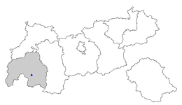
 Location within Tyrol | |
| Coordinates: 46°58′00″N 10°33′00″E / 46.96667°N 10.55000°E | |
| Country | Austria |
| State | Tyrol |
| District | Landeck |
| Government | |
| • Mayor | Melanie Zerlauth |
| Area | |
| • Total | 140.53 km2 (54.26 sq mi) |
| Elevation | 970 m (3,180 ft) |
| Population (2018-01-01)[2] | |
| • Total | 2,602 |
| • Density | 19/km2 (48/sq mi) |
| Time zone | UTC+1 (CET) |
| • Summer (DST) | UTC+2 (CEST) |
| Postal code | 6542 |
| Area code | 05474 |
| Vehicle registration | LA |
| Website | www.pfunds.tirol.gv.at |
Pfunds is a municipality in the district of Landeck in the Austrian state of Tyrol located 19.7 km south of the city of Landeck and 5 km north of the border to Switzerland. The village was first mentioned in documents in 1282. The main source of income is tourism.

Geography
[edit]Populated places
[edit]The municipality of Kirchdorf consists of the following populated places; the first two are villages while the rest are hamlets.[3]
- Pfunds-Stuben
- Pfunds-Dorf
- Airsch
- Birkach
- Greit
- Hinterkobel
- Kobl
- Lafairs
- Margreid
- Mariastein
- Rauth
- Schönegg
- Stein
- Vorderkobel
- Wand
References
[edit]- ^ "Dauersiedlungsraum der Gemeinden Politischen Bezirke und Bundesländer - Gebietsstand 1.1.2018". Statistics Austria. Retrieved 10 March 2019.
- ^ "Einwohnerzahl 1.1.2018 nach Gemeinden mit Status, Gebietsstand 1.1.2018". Statistics Austria. Retrieved 9 March 2019.
- ^ Pfunds - Gemeinde - Startseite - Gemeindeamt - Web - Suche
Wikimedia Commons has media related to Pfunds.


