Planetal
Appearance
Planetal | |
|---|---|
 Church of the former Teutonic order in Dahmsdorf quarter | |
Location of Planetal within Potsdam-Mittelmark district  | |
| Coordinates: 52°07′00″N 12°40′59″E / 52.11667°N 12.68306°E | |
| Country | Germany |
| State | Brandenburg |
| District | Potsdam-Mittelmark |
| Municipal assoc. | Niemegk |
| Subdivisions | 4 Ortsteile |
| Government | |
| • Mayor (2024–29) | Karin Commichau[1] |
| Area | |
| • Total | 42.52 km2 (16.42 sq mi) |
| Elevation | 70 m (230 ft) |
| Population (2022-12-31)[2] | |
| • Total | 914 |
| • Density | 21/km2 (56/sq mi) |
| Time zone | UTC+01:00 (CET) |
| • Summer (DST) | UTC+02:00 (CEST) |
| Postal codes | 14806 |
| Dialling codes | 033841, 033843 |
| Vehicle registration | PM |
| Website | www.amt-niemegk.de |
Planetal is a municipality in the Potsdam-Mittelmark district, in Brandenburg, Germany.
History
[edit]From 1815 to 1947, the constituent localities of Planetal were part of the Prussian Province of Brandenburg. From 1952 to 1990, they were part of the Bezirk Potsdam of East Germany. On 1 July 2002, the municipality of Planetal was formed by merging the municipalities of Dahnsdorf, Kranepuhl, Mörz and Locktow.
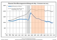
Demography
[edit]
|
|
References
[edit]- ^ Landkreis Potsdam-Mittelmark Wahl der Bürgermeisterin / des Bürgermeisters. Retrieved 10 July 2024.
- ^ "Bevölkerungsentwicklung und Bevölkerungsstandim Land Brandenburg Dezember 2022" (PDF). Amt für Statistik Berlin-Brandenburg (in German). June 2023.
- ^ Detailed data sources are to be found in the Wikimedia Commons.Population Projection Brandenburg at Wikimedia Commons


