Prabumulih
Prabumulih | |
|---|---|
| City of Prabumulih Kota Prabumulih | |
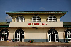
 A railway station in the city of Prabumulih, South Sumatra | |
| Nickname: Kota Nanas (Indonesian : Pineapple City) | |
| Motto: Seinggok Sepemunyian | |
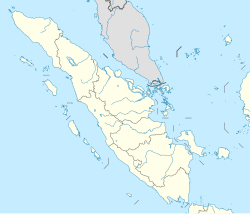
 Location within South Sumatra | |
| Coordinates: 3°25′58″S 104°14′8″E / 3.43278°S 104.23556°E | |
| Country | |
| Region | Sumatra |
| Province | |
| Government | |
| • Mayor | Ridho Yahya |
| • Vice Mayor | Andriansyah Fikri |
| Area | |
• Total | 447.31 km2 (172.71 sq mi) |
| Population (mid 2023 estimate)[1] | |
• Total | 200,673 |
| • Density | 450/km2 (1,200/sq mi) |
| Time zone | UTC7 (Indonesia Western Time) |
| Area code | (+62) 713 |
| Website | kotaprabumulih.go.id |
Prabumulih is a city in South Sumatra, Indonesia. It was originally part of Muara Enim Regency, from which it was separated to become an independent city on 21 June 2001. It has an area of 447.31 km² and had a population of 161,814 at the 2010 Census[2] and 193,196 at the 2020 Census;[3] the official estimate as at mid 2023 was 200,673 (comprising 100,908 males and 99,765 females).[1] Geographically, this city is located at 3°25′58″S 104°14′8″E in the heart of the province, and it is surrounded on all sides by Muara Enim Regency, apart from a short stretch bordering Penukal Abab Lematang Ilir Regency.
City borders
[edit]Administrative districts
[edit]Prabumulih is administratively divided into six districts (kecamatan), tabulated below with their areas and their populations at the 2010 Census[2] and the 2020 Census,[3] together with the official estimates as at mid 2023.[1] The table also includes the location of the district administrative centres, the number of administrative villages in each district (a total of 12 classed as rural desa and 25 as urban kelurahan), and its postal codes.
| Kode Wilayah |
Name of District (kecamatan) |
Area in km2 |
Pop'n Census 2010 |
Pop'n Census 2020 |
Pop'n Estimate mid 2023 |
Admin centre |
Density per km2 (2022) |
No. of kelu- rahan |
No. of desa |
Post codes |
|---|---|---|---|---|---|---|---|---|---|---|
| 16.74.04 | Rambang Kapak Tengah | 125.56 | 10,881 | 12,805 | 13,098 | Tanjung Rambang | 164.7 | 1 | 8 | 31131 - 31135 |
| 16.74.02 | Prabumulih Timur (East Prabumulih) |
70.07 | 57,044 | 78,032 | 83,560 | Prabujaya | 558.6 | 8 | - | 31111 - 31117 |
| 16.74.06 | Prabumulih Selatan (South Prabumulih) |
48.69 | 17,014 | 21,136 | 21,963 | Tanjung Raman | 205.3 | 3 | 1 | 31112 - 31134 |
| 16.74.01 | Prabumulih Barat (West Prabumulih) |
125.32 | 29,569 | 30,588 | 30,832 | Patih Galung | 456.7 | 5 | 1 | 31121 - 31123 |
| 16.74.05 | Prabumulih Utara (North Prabumulih) |
10.95 | 31,524 | 31,673 | 31,736 | Wonosari | 2,618.3 | 5 | - | 31121 - 31126 |
| 16.74.03 | Cambai | 66.72 | 15,952 | 18,962 | 19,484 | Cambai | 300.1 | 3 | 2 | 31141 - 31145 |
| Totals | 447.31 | 161,984 | 193,196 | 200,673 | 417.2 | 25 | 12 |
Economy
[edit]Prabumulih is one of main producers of crude oil and natural gas in South Sumatra. The city is known as "kota nanas" (Pineapple City) because this is known as a centre for pineapple production in the region.
Airports
[edit]There used to be an airport in Prabumulih, which is no longer active.
References
[edit]External links
[edit]- (in Indonesian) Official website
- (in Indonesian) Prabumulih blogger
3°25′58″S 104°14′8″E / 3.43278°S 104.23556°E


