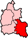
South Oxfordshire
| South Oxfordshire District | |
|---|---|
 Lage in Oxfordshire | |
| Status | District |
| Region | South East England |
| Verw.grafschaft | Oxfordshire |
| Verwaltungssitz | Wallingford |
| Fläche | 678,53 km² (57.) |
| Einwohner | 128.400 (153.) |
| ONS-Code | 38UD |
| Website | www.southoxon.gov.uk |
South Oxfordshire ist ein District in der Grafschaft Oxfordshire in England. Verwaltungssitz ist Wallingford; weitere bedeutende Orte sind Didcot, Henley-on-Thames und Thame.
Geschichte
[Bearbeiten | Quelltext bearbeiten]Der Bezirk wurde am 1. April 1974 gebildet und entstand aus der Fusion der Municipal Boroughs Henley-on-Thames und Wallingford, des Urban District Thame sowie der Rural Districts Bullingdon, Henley und Wallingford. Das Gebiet um Wallingford gehörte zuvor zur Verwaltungsgrafschaft Berkshire.
Gliederung
[Bearbeiten | Quelltext bearbeiten]Der Bezirk gliedert sich in 87 Gemeinden (Civil Parish):
|
|
|
Von diesen haben 75 einen eigenen, Aston Tirrold und Aston Upthorpe einen gemeinsamen Gemeinderat (Parish Council). Die übrigen 11 haben kein derartiges Gremium, stattdessen finden Einwohnerversammlungen statt. Didcot, Henley-on-Thames, Thame und Wallingford sind Kleinstädte (Town), dementsprechend heißt der Rat dort Town Council.[1]
Weblinks
[Bearbeiten | Quelltext bearbeiten]- Offizielle Website des District Councils (englisch)
- Statistische Daten auf Basis der Volkszählung 2011 auf der Website des Office for National Statistics (englisch)
- District South Oxfordshire in der Datenbank des Ordnance Survey (englisch)
Einzelnachweise
[Bearbeiten | Quelltext bearbeiten]- ↑ Parish council contact details auf der Website des Districts, abgerufen am 29. März 2018 (englisch)
Koordinaten: 51° 39′ N, 1° 3′ W