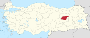
Tunceli Province
Tunceli Province Tunceli ili | |
|---|---|
 Location of Tunceli Province in Turkey | |
| Kintra | Turkey |
| Region | Eastren Anatolie |
| Govrenment | |
| • Electoral destrict | Tunceli |
| Area | |
| • Tot | 7,774 km2 (3,002 sq mi) |
| Population (2010)[1] | |
| • Tot | 82,193 |
| • Density | 11/km2 (27/sq mi) |
| Area code(s) | 0428[2] |
| Vehicle registration | 62 |
The Tunceli Province (Kurdish: Parêzgeha Dêrsimê, Turkis: Tunceli ili) is a province in the Eastren Anatolie Region o Turkey. The province wis namit Dersim Province (Dersim vilayeti , Dersim meanin 'siller door' in Zazaki an Kurmanci) an wis chyngit tae Tunceli Province on 4 Januar 1936.[3] wi the "Law on Admeenistration o the Tunceli Province" (Tunceli Vilayetinin İdaresi Hakkında Kanun), no. 2884 o 25 December 1935.[4][5][6] But some still caw the region bi this name. The caipital ceety is Tunceli. The name o the provincial caipital, Kalan, wis then offeecially chyngit tae match wi the province's name.
Its adjacent provinces are Erzincan tae the north an wast, Elazığ tae the sooth, an Bingöl tae the east. The province covers an aurie o 7,774 km2 (3,002 sq mi) an haes a population o 76,699. It haes the lawest population densitie o ony province in Turkey, juist 9.8 indwallers/km². Tunceli is the anerlie Turkis province wi an Alevi majority.
Tunceli is kent for its auld biggins sic as the Çelebi Ağa Mosque, Sağman Mosque, Elti Hatun Mosque an adjoinin Tomb an impressive naitural scenery, especially in Munzur Valley Naitional Pairk, the lairgest naitional pairk o Turkey.
Geography
[eedit | eedit soorce]Tunceli is traversed bi the northeasterly line o equal latitude an langitude.
History
[eedit | eedit soorce]The history o the province stretches back tae antiquity. It haes been mentioned as 'Daranalis' bi Ptolemy, an seeminly, it wis referred tae as 'Daranis' afoere him. Ane theory as tae the oreegin o the name associates wi the Persie Emperor Darius.
The aurie that wad acome Tunceli province formit pairt o Urartu, Media, the Achaemenid Empire, an the Greater Armenie region o Sophene. Sophene wis later contestit bi the Roman an Parthian Empires an bi thair respective successors, the Byzantine an Sassanid Empires. Arabs invadit in the 7t century, an Seljuq Turks in the 11t.[7]
As o the end o the 19t century, the region (cried "Dersim") wis includit in the Ottoman sancak (subprovince) o Hozat, dependin the ceety an the province o Mamuret-ül Aziz (Elazığ the day), wi the exception o the actual destrict o Pülümür, which dependit on the neebourin sancak o Erzincan, then a pairt o the Erzurum Province. This status continued throu the first years o the Republic o Turkey, till 1936 when the name o the province ("Dersim") wis chyngit tae Tunceli, literally 'the land o bronze' in Turkis (tunç meanin 'bronze' an el (in this context) meanin 'land') efter the Dersim Rebellion. The centre o the province haes been fixed in the toun o Kalan an the destrict o Pülümür haes been addit athin the bundaries o the new province.
Destricts
[eedit | eedit soorce]Tunceli province is dividit intae aicht destricts (caipital destrict in bauld):
Awtho a destinct province, Tunceli wis admeenistered frae Elazığ till 1947.
Ceeties an touns
[eedit | eedit soorce]- Tunceli 31,599 inh.
- Pertek 6,341 inh.
- Hozat 4,714 inh.
- Ovacık 3,227 inh.
- Çemişgezek 2,819 inh.
- Akpazar 1,769 inh.
- Mazgirt 1,712 inh.
- Pülümür 1,656 inh.
- Nazımiye 1,636 inh.
Education
[eedit | eedit soorce]Ninety-aicht percent o Tunceli's population haes at least a primary schuil eddication, leadin tae ane o the heichest rates o literacy for a destrict athin Turkey. In 1979/1980 Tunceli haed the heichest nummer o students attendin varsities as well as the tap entry pynts till the anerlie heicher eddication schuil shut doun an convertit tae a militar base.
Tunceli Varsity wis established on 22 Mey 2008.[8] It haes depairtments in internaitional relations, economics, environmental pertection ingineerin, industrial ingineerin, electronic ingineerin, computer ingineerin an mechanical ingineerin.
References
[eedit | eedit soorce]- ↑ Turkish Statistical Institute, MS Excel document – Population of province/district centers and towns/villages and population growth rate by provinces
- ↑ Area codes page of Turkish Telecom website (in Turkis)
- ↑ Paul J. White, Primitive rebels or revolutionary modernizers?: the Kurdish national movement in Turkey, Zed Books, 2000, ISBN 978-1-85649-822-7, p. 80.
- ↑ New perspectives on Turkey, Issues 1-4, Simon's Rock of Bard College, 1999 p. 15.
- ↑ Victoria Arakelova, "The Zaza People as a New Ethno-Political Factor in the Region" - in – “Iran & the Caucasus: Research Papers from the Caucasian Centre for Iranian Studies, Yerevan”, vols.3-4, 1999-2000, pp. 197-408.
- ↑ G.S. Asatrian, N.Kh. Gevorgian. Zaza Miscellany: Notes on some Religious Customs and Institutions. – A Green Leaf: Papers in Honour of Prof. J. P. Asmussen (Acta Iranica - XII). Leiden, 1988, pp. 499-508
- ↑ Seyfi Cengiz Tarih (2005). History.[deid airtin]
- ↑ Tunceli University Signs Protocol with 4 American Universities[deid airtin]
Freemit airtins
[eedit | eedit soorce]- Offeecial Hamepage o the Province Govrenor
- Offeecial Homepage o the Cultur an Tourism heid office
- Offeecial Hamepage o the polis heid office[deid airtin]
- Offeecial Hamepage o the Education heid office
- Offeecial Hamepage o the health heid office Archived 2008-06-18 at the Wayback Machine
- Education Archived 2014-08-05 at the Wayback Machine
Coordinates: 39°12′53″N 39°28′17″E / 39.21472°N 39.47139°E


