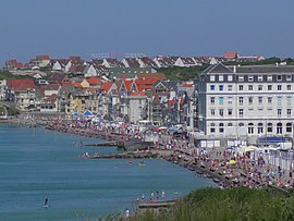
Wimereux
You can help expand this article with text translated from the corresponding article in French. (December 2020) Click [show] for important translation instructions.
|
Wimereux
Wimeruwe | |
|---|---|
 Wimereux | |
| Coordinates: 50°46′N 1°37′E / 50.77°N 1.61°E | |
| Country | France |
| Region | Hauts-de-France |
| Department | Pas-de-Calais |
| Arrondissement | Boulogne-sur-Mer |
| Canton | Boulogne-sur-Mer-1 |
| Intercommunality | Boulonnais |
| Government | |
| • Mayor (2020–2026) | Jean-Luc Dubaële[1] |
Area 1 | 7.71 km2 (2.98 sq mi) |
| Population (2021)[2] | 6,358 |
| • Density | 820/km2 (2,100/sq mi) |
| Time zone | UTC+01:00 (CET) |
| • Summer (DST) | UTC+02:00 (CEST) |
| INSEE/Postal code | 62893 /62930 |
| Elevation | 0–71 m (0–233 ft) |
| 1 French Land Register data, which excludes lakes, ponds, glaciers > 1 km2 (0.386 sq mi or 247 acres) and river estuaries. | |
Wimereux (French: [vim(ə)ʁø]; West Flemish: Wimeruwe) is a commune in the Pas-de-Calais department in the Hauts-de-France region of France[3] 5 kilometres (3 mi) north of Boulogne-sur-Mer, on the banks of the small river Wimereux. The river Slack forms the northern border of the commune and the English Channel the western.
History
[edit]In March 1899 the first radio link between France and England was established at Wimereux by Guglielmo Marconi.[4]
Lady Hadfield set up and ran a Red Cross hospital there.[5] The Women's Hospital Corps, founded by Flora Murray and Louisa Garratt Anderson, opened its second hospital in Wimereux. It was the first women's hospital to be recognised by the British Army.[6] In 1916, Solomon J Solomon set up a Royal Engineers establishment, the Special Works Park, in a disused feldspar factory and developed new military camouflage techniques and equipment for the British Army.[7]
People
[edit]- William Morrison Wyllie, English artist
- Lionel Percy Smythe (Wyllie's stepson), English landscape artist, lived there from 1879 to 1918
- Alfred Mathieu Giard, director of the marine research establishment at Wimereux
- John McCrae, author of "In Flanders Fields", is buried in the CWGC cemetery[8]
- Jack Lang, politician
- Maurice Boitel, artist, exhibited there in the 1980s and 1990s
Twin towns
[edit]Wimereux is twinned with the following towns:
 Herne Bay, Kent, England
 Schmallenberg, Germany
Population
[edit]| Year | Pop. | ±% p.a. |
|---|---|---|
| 1968 | 5,241 | — |
| 1975 | 6,712 | +3.60% |
| 1982 | 7,023 | +0.65% |
| 1990 | 7,109 | +0.15% |
| 1999 | 7,493 | +0.59% |
| 2007 | 7,398 | −0.16% |
| 2012 | 7,161 | −0.65% |
| 2017 | 6,575 | −1.69% |
| Source: INSEE[9] | ||
Gallery
[edit]-
The beach at Wimereux
-
Beach huts
-
The west front of the church
-
The war memorial
-
The seafront promenade
-
Villa «La Frégate»
-
Villas on the seafront
-
Villa «De Sonis»
-
Plaque commemorating wireless link-up between France and England
-
High tide along the beachfront
-
The beach crowded with people at lower tide
See also
[edit]References
[edit]- ^ "Répertoire national des élus: les maires". data.gouv.fr, Plateforme ouverte des données publiques françaises (in French). 9 August 2021.
- ^ "Populations légales 2021" (in French). The National Institute of Statistics and Economic Studies. 28 December 2023.
- ^ INSEE commune file
- ^ "Guglielmo Marconi". National Trust. Retrieved 15 March 2016.
- ^ "Lady Hadfield, Obituary". The Times. 8 November 1949.
- ^ GEDDES, JENNIAN F (1 January 2007). "Deeds and Words in the Suffrage Military Hospital in Endell Street". Medical History. 51 (1): 79–98. doi:10.1017/s0025727300000909. ISSN 0025-7273. PMC 1712367. PMID 17200698.
- ^ Rankin, Nicholas (2008). Churchill's Wizards - the British genius for deception, 1914 - 1945. London: Faber and Faber. p. 86. ISBN 978-0-571-22195-0.
- ^ The CWGC cemetery
- ^ Population en historique depuis 1968, INSEE
External links
[edit]- Website about Wimereux (English only)
- Official town website (French only)
- Official Tourist website (French only)
- Official website: Tourism in Boulogne and the Boulonnais region


