Woryny
Woryny | |
|---|---|
Village | |
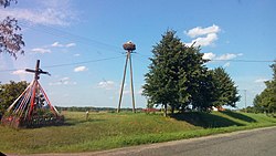
 Wood storks nest in Woryny | |
| Coordinates: 54°18′31″N 20°34′12″E / 54.30861°N 20.57000°E | |
| Country | |
| Voivodeship | Warmian-Masurian |
| County | Bartoszyce |
| Gmina | Górowo Iławeckie |
Woryny [vɔˈrɨnɨ] is a village in the administrative district of Gmina Górowo Iławeckie, within Bartoszyce County, Warmian-Masurian Voivodeship, in northern Poland, close to the border with the Kaliningrad Oblast of Russia.[1]
History
[edit]On the south-west edge of the village there are traces of a settlement known as Góra Zamkowa (Castle Hill), most likely what was described in medieval documents as Woria or Wore, existing in the pre-Teutonic Knights period. The stronghold in Woryny took advantage of the defensive qualities of being situated at the top of a hill overlooking a stream. The two-part settlement is separated by a dry moat and was most likely inhabited only in one part, with farm animals kept in the second fragment.[2]
Throughout the Napoleonic Battle of Eylau in February 1807 the French generals Nicolas Dahlmann (General Colonel, Commandant des chasseur à cheval de la Garde Impériale francaise) and Jean-Joseph Ange d'Hautpoul were buried at the manor house of Worienen but later exhumed and transferred to France.[3]
References
[edit]- ^ "Central Statistical Office (GUS) - TERYT (National Register of Territorial Land Apportionment Journal)" (in Polish). 2008-06-01.
- ^ Gmina Górowo Iławeckie. "Przewodnik Gmina Górowo Iławeckie" (PDF).
- ^ extract of the Church records

