Slezské Rudoltice
Slezské Rudoltice | |
|---|---|
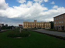
 Centre of Slezské Rudoltice | |
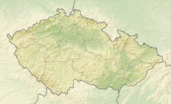
| Coordinates: 50°12′25″N 17°40′52″E / 50.20694°N 17.68111°E | |
| Country | |
| Region | Moravian-Silesian |
| District | Bruntál |
| First mentioned | 1255 |
| Area | |
• Total | 23.22 km2 (8.97 sq mi) |
| Elevation | 275 m (902 ft) |
| Population (2024-01-01)[1] | |
• Total | 504 |
| • Density | 22/km2 (56/sq mi) |
| Time zone | UTC+1 (CET) |
| • Summer (DST) | UTC+2 (CEST) |
| Postal code | 793 97 |
| Website | www |
Slezské Rudoltice (German: Rosswald) is a municipality and village in Bruntál District in the Moravian-Silesian Region of the Czech Republic. It has about 500 inhabitants.
Administrative parts
[edit]The villages of Amalín, Koberno and Víno are administrative parts of Slezské Rudoltice.
Geography
[edit]Slezské Rudoltice is located about 28 kilometres (17 mi) northeast of Bruntál and 56 km (35 mi) northwest of Ostrava. It is situated in the Osoblažsko microregion on the border with Poland. It lies in the Zlatohorská Highlands. The Lužná stream, a tributary of the Osoblaha, originates in the western part of the municipal territory and flows across the territory.
History
[edit]The first written mention of Rudoltice is from 1255. It was one of the settlements that were founded in the area shortly before at the initiative of the bishop Bruno von Schauenburg. The area was then settled by German colonizers.[2]
The local medieval fortress was rebuilt into a small Renaissance castle in 1548–1565. In 1630, after the Rudoltice fief was shortly owned by Maximilian, Prince of Dietrichstein, it was acquired by the Counts of Hodice. From 1661 to 1778, Rudoltice was an estate associated in particular with Albert of Hodice (1706–1778), thanks to which it flourished. He had rebuilt the castle in the Baroque style and turned Rudoltice a cultural centre of Silesia. Rudoltice began to be nicknamed "Silesian Versailles" and among the guests at the castle were the composer Carl Ditters von Dittersdorf or the Prussian king Frederick the Great. However, Albert of Hodice indebted the estate, and therefore it had to be divided and sold out in order to pay off debts. Valuable things and furniture from the castle were also sold out.[2][3]
In 1938, Rudoltice was annexed by Nazi Germany and administered as a part of Reichsgau Sudetenland. After World War II, the German population was expelled and the village was resettled by Czechs.[2] The neighbouring village of Pelhřimovy was razed to the ground after the Germans left and disappeared.[4]
The current municipality of Slezské Rudoltice was created in 1947 by merger of Městys Rudoltice and Ves Rudoltice (including Amalín). In 1949, the villages of Víno and Nový Les, and the area of the abandoned village of Pelhřimovy were joined to the municipality. In 1960, Koberno was joined.[2]
Demographics
[edit]
|
|
| ||||||||||||||||||||||||||||||||||||||||||||||||||||||
| Source: Censuses[5][6] | ||||||||||||||||||||||||||||||||||||||||||||||||||||||||
Transport
[edit]Slezské Rudoltice is located on the narrow-gauge Třemešná ve Slezsku–Osoblaha railway. The municipality is served by three stops: Amalín, Slezské Rudoltice and Koberno. However, the Koberno stop is located outside the municipal territory.
Sights
[edit]
The main landmark is Slezské Rudoltice Castle. Since 2008 it has been owned by the municipality which opened it to public.[3] Part of the castle is a small park of French and English type with a pond.[7]
The second landmark of the municipality is the Church of Saint Catherine. An originally Romanesque church in Rudoltice was first documented in the late 17th century. The church fell into disrepair and was demolished in 1871, and the new Neo-Romanesque church was built on its site in 1871–1874.[8][9]
In Pelhřimovy there is the Gothic Church of Saint George from the 15th century, together with two cottages and a ruined cemetery the last remains of the abandoned village.[4]
The narrow-gauge railway serves not only for transport but also as a tourist attraction. Steam trains run on weekends during the tourist season.[10]
References
[edit]- ^ "Population of Municipalities – 1 January 2024". Czech Statistical Office. 2024-05-17.
- ^ a b c d "Historie obce" (in Czech). Obec Slezské Rudoltice. Retrieved 2022-03-25.
- ^ a b "Historie zámku" (in Czech). Slezské Rudoltice Castle. Retrieved 2022-03-25.
- ^ a b "Zaniklá obec Pelhřimovy s kostelem sv. Jiří u Slezských Rudoltic" (in Czech). CzechTourism. Retrieved 2022-03-25.
- ^ "Historický lexikon obcí České republiky 1869–2011" (in Czech). Czech Statistical Office. 2015-12-21.
- ^ "Population Census 2021: Population by sex". Public Database. Czech Statistical Office. 2021-03-27.
- ^ "Zámecké zahrady" (in Czech). Slezské Rudoltice Castle. Retrieved 2022-03-25.
- ^ "Kostel sv. Kateřiny" (in Czech). Obec Slezské Rudoltice. Retrieved 2022-03-25.
- ^ "Kostel sv. Kateřiny ve Slezských Rudolticích" (in Czech). CzechTourism. Retrieved 2022-03-25.
- ^ "Úzkorozchodná železnice Třemešná – Osoblaha" (in Czech). CzechTourism. Retrieved 2022-03-25.


