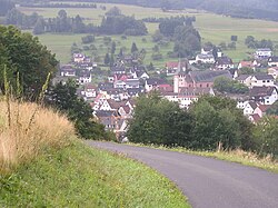
Frammersbach
Frammersbach | |
|---|---|
 Frammersbach from Bäckersberg ("Baker's Hill") | |
| Coordinates: 50°4′N 9°28′E / 50.067°N 9.467°E | |
| Country | Germany |
| State | Bavaria |
| Admin. region | Lower Franconia |
| District | Main-Spessart |
| Government | |
| • Mayor (2017–23) | Christian Holzemer[1] |
| Area | |
| • Total | 19.20 km2 (7.41 sq mi) |
| Elevation | 246 m (807 ft) |
| Population (2022-12-31)[2] | |
| • Total | 4,597 |
| • Density | 240/km2 (620/sq mi) |
| Time zone | UTC+01:00 (CET) |
| • Summer (DST) | UTC+02:00 (CEST) |
| Postal codes | 97833 |
| Dialling codes | 0 93 55 |
| Vehicle registration | MSP |
| Website | www.frammersbach.de |
Frammersbach is a market community in Main-Spessart in the Regierungsbezirk of Lower Franconia (Unterfranken) in Bavaria, Germany. In the early modern period, people from Frammersbach achieved international fame as drivers of wagons on the most important trans-European trade routes. Today, Frammersbach has a population of about 4,500.
Geography
[change | change source]Location
[change | change source]This state-recognized resort (staatlich anerkannter Erholungsort) is between Würzburg and Aschaffenburg, in the middle of the Spessart Nature Park (Naturpark Spessart).
The municipal territory borders on the state of Hesse in places and is not continuous: Habichsthal is separated from Frammersbach proper by the wooded unincorporated area of the Frammersbacher Forst. On all other sides, the village is surrounded by the Heinrichsthaler Forst (placed in the neighbouring Aschaffenburg district).
Frammersbach is in the valley of the Lohr river, while Habichsthal is in a side valley of the Aubach, which flows into the Lohr at Partenstein. Out of a total municipal area of around 2,000 hectares, about 700 hectares are covered by communally-owned forest.
Nearby hills are the Wellersberg, Eichenberg and the Hermannskoppe.
Subdivisions
[change | change source]The community has the following Gemarkungen (traditional rural cadastral areas): Frammersbach and Habichsthal. These are also Frammersbach's two Ortsteile (boroughs).
The former villages Herbertshain, Hofreith and Schwartel have been took into Frammersbach proper.
Neighbouring communities
[change | change source]The neighbouring communities are from the north, clockwise: Flörsbachtal (Hesse), the unincorporated areas Haurain and Frammersbacher Forst, Partenstein, Partensteiner Forst (unincorporated area), Wiesthal, Heinrichsthaler Forst (unincorporated area), again Frammersbacher Forst and finally Wiesen.
Other websites
[change | change source]- Community’s official webpage (in German)
- Waggoners’ and Tailors’ Museum (in German)
References
[change | change source]- ↑ Liste der ersten Bürgermeister/Oberbürgermeister in kreisangehörigen Gemeinden, Bayerisches Landesamt für Statistik, accessed 19 July 2021.
- ↑ Genesis Online-Datenbank des Bayerischen Landesamtes für Statistik Tabelle 12411-003r Fortschreibung des Bevölkerungsstandes: Gemeinden, Stichtag (Einwohnerzahlen auf Grundlage des Zensus 2011) .


